|
||

|

|
|

|
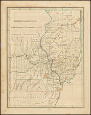
First United States Land Office Survey West of the Mississippi River -- Signed by Gardiner with his Field Notes!
Rare and important map of a portion of Missouri Territory, at the confluence of the Mississippi and Missouri Rivers, published by John Gardiner circa 1819.
Gardiner, who was then serving as the Chief Clerk in the General Land Office, created this map as means of illustrating the military bounty lands near the Missouri River, about 100 miles west of the Mississippi River, which were intended to be offered to veterans of the War of 1812 beginning in about 1819. To do so, Gardiner incorporated the surveys conducted under the direction of St. Louis based William Rector, Principal Deputy Surveyor General for the Missouri Territory the earliest such survey work west of the Mississippi River.
Gardiner's map is almost certainly the earliest map showing American surveys of public lands in Missouri Territory and, as such, the first American township and range survey West of the Mississippi River. As noted by Streeter:
"The surveyed townships at the most northern point are only about 80 miles north of the parallel of St. Louis and the only settlements shown on the Missouri River are St. Charles, near its mouth, Franklin, and Boon's Lick Settlement. On the west side of the Mississippi the towns, from north to south, are St. Louis, Carondeleto, Rogers-town, Herculaneum, St. Genevieve, Potosi, Old Shawnee Village, Mine a la Motte, Little Delaware Village, Jackson, and Cape Giradeau." (Streeter III:1841).
Two areas of bounty lands are noted on this map - one between the Illinois River and the Mississippi labeled "Military Bounty Land in Illinois Territory" (which had been the subject of a map by Gardiner issued circa 1817) and an area west of the Mississippi on the Missouri River simply labeled "Military Bounty Lands." The townships are platted out from the Salt River to nearly Cape Girardeau, and west to just beyond Boons Lick Settlement. A map of a typical (or maybe ideal) township with sections noted on the east side of the Illinois River, above and to the right of St.Louis.
As noted below, because Congress would go on to reject Gardiner's proposal to give each a copy of this map to War of 1812 veterans interested in claiming land in the Missouri Bounty Lands, very few examples of the map survive today.
Annotations in the Hand of John Gardiner and Signed by Gardiner
The map was issued with a number of blanks, which were intended to be filled in by hand at a later time. The few surviving examples of the map are found without most, if not all of the information blank. However, the present example includes handwritten additions that we have never previously encountered.
While it is not unusual to have the Bounty Lands outlined in color, the present example fills in all the blanks, allowing for an exact location of the lands in question. The specific township and survey are given (Township 59 West, Range 23 West), the specific description is given (Southwest 1/4 of Section 13) and there is a specific description of the land, which appears to be in the hand of John Gardiner, who has signed (not just initialled) this example.
While we have encountered the occasional example of the map Gardiner's initials, most if not all of the information is normally blank.
Historical Overview
After the War of 1812, Edward Tiffin, Surveyor General Northwest of the Ohio, was directed by Congress in 1815 to survey land in Illinois, Michigan, and Missouri Territories, as part of the plan to give some of the lands to veterans of the war. In 1813, William Rector was appointed Principal Deputy Surveyor General for the Missouri Territory. After determining that the lands in Michigan Territory were not suitable, the planned survey was restructured, thereafter requiring the survey of 3.5 million acres in Illinois Territory and 2.5 million acres in Missouri Territory.
Congress's plan called was intended to reward military service by entitling veterans to claim land, known as "bounty land," through a multi-step process beginning with the issuance of Bounty Land Warrants. The veterans applied for warrants and if it granted, used the warrants to apply for land patents.
The survey of the Illinois Bounty Lands, lying east of the Mississippi River, was completed by 1817. John Gardiner, Chief Clerk in the General Land Office, published a map of the Illinois Bounty Lands in 1817, intended to aid in the process of claiming land. The survey and processing of the Bounty Lands in Missouri proved more problematic. French settlers west of the Mississippi River held claims to lands predating the Louisiana Purchase. The Missouri surveys were completed by 1818, but it would take another three years to address the French claims and other ancillary issues.
Based upon Congressional debates which occurred in December 1818, it is probable that the Map of the Northern Part of Missouri Territory was prepared by Gardiner on his own account, in 1818, but the land title issues likely frustrated his initial plan to give away copies of the map to veterans.
While the map was never distributed as Gardiner envisioned, it remains an historical landmark in the opening of the Transmississippi West. Thomas Streeter notes that the map is likely the earliest printed map of a portion of Missouri Territory and perhaps the first map to show the progress of township surveys west of the Mississippi River.
John Gardiner
John Gardiner was the chief clerk of the General Land Office during the War of 1812. Among the more noteworthy events attributed to Gardiner was his removal of the General Land Office records from Washington by carriage, during the siege by the British.
Gardiner's name appears on several early maps, including a Map of the Bounty Lands in Illinois Territory, a map of the military boundary lands in Arkansas Territory, a similar map of Alabama Territory and the present map of the Northern Part of Missouri Territory.
Printing History of Gardiner's Maps
While Gardiner's map of the bounty lands in Illinois Territory appears occasionally on the market, the remaining maps are extremely rare. This is perhaps due to Congress's refusal to publish the map and provide copies to military veterans. As noted below, Gardiner's suggestion that copies of the map of Missouri Territory be provided to veterans was considered and rejected by Congress.
The Debates and Proceedings in the Congress of the United States at page 39 notes that on Monday, December 7, 1818, "The President communicated a letter from John Gardiner, presenting to the Senate maps of the Alabama Territory and of the military bounty lands in the Missouri Territory. . . " Similarly at page 346, it is noted that "The Speaker laid before the House a letter from John Gardiner, enclosing a map of Alabama and of military bounty lands in Missouri, and stating that if Congress thinks proper to give to each soldier a map with his bounty land, he is willing to relinquish his impression on reasonable terms. . . " On December 9, 1818, Mr. Poindexter of the Committee of Public Lands "made a report unfavorable to the proposition of John Gardiner to supply soldiers with maps of their bounty lands at a reasonable price. . . "
The map notes that it was Entered according to act of Congress by John Gardiner, Distt. Columa. It is possible that Gardiner himself printed the map. We are not aware of any publishers or engravers operating in Washington DC who were capable of printing the map and none of Gardiner's maps indicate a place of publication or engraver name.
In October 2011, we handled several other Gardiner maps from the same "series." Based upon information discovered in 2011, it is possible that Gardiner's maps were published in Philadelphia by Tanner, Vallence, Kearny & Co., which printed maps of the Northern and Southern Districts of Alabama Territory for Gardiner at approximately the same time as this map and the Bounty Lands in Illinois Territory map) and this map.
Rarity
The map is extremely rare, As of 2011, OCLC noted 2 examples (Newberry Library (Streeter Copy) and University of Kentucky). We note also that the Dr. Kenneth J. LaBudde Department of Special Collections, University of Missouri Kansas City Miller Nichols Library, lists an example of the map in its online holdings.
In 2011, we acquired several examples of the map from the deaccession of an institutional collection.
![[ The Old Northwest Territory ] Il Paese De Selvaggi Outagamiani, Mascoutensi Illinesi E parte Delle VI Naxioni](https://storage.googleapis.com/raremaps/img/small/75927.jpg)