|
||

|

|
|

|
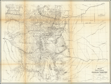
An Early Township and Range Map of Summit County, Colorado
Interesting 20th-century manuscript map of part of central Colorado, including Breckenridge and Keystone, among other places
A very interesting topographical map of the area centered on the continental divide, which provides a fine overview of the existing and proposed transportation routes through the region, including wagon roads, railroads and proposed railroad lines (Colorado & Southern Railway, Denver & South Park Railroad and Denver & Rio Grande Railroad are named).
The map focuses on the area south of Georgetown. Argentine Pass appears at the top right, Dillon at the top left, and Fairplay at the bottom left, with Jefferson Lake and Georgia Pass at the center of the map.
An interesting array of colors is employed, with mountains in blue, rivers and creeks in purple, railroads in red (existing railroads are noted with cross hatches, proposed lines are dotted) and wagon roads in orange. A few details are added in pen, such as the heights of mountains.
The "Surveyed and Partly Graded Route" of the C & S RR is shown running from Keystone toward Montezuma and Chihuahua, while a Proposed RR between Montezuma and Chihuahua is also shown. The Wagon Road to Silver Plume is named. The Wagon Road to Georgetown north of Argentine Pass and near the Santiago Mine is also shown.
A "Proposed Railroad" is shown extending north from Grant toward Geneva, with a Wagon road along the Platte River also noted. In the southwest, a Wagon road is shown between Breckenridge and Alma via Hoosier Pass.
Rarity
The map is unrecorded.
![[ Colorado Atlas -- Presentation Copy ] Geological and Geographical Atlas of Colorado and Portions of Adjacent Territory](https://storage.googleapis.com/raremaps/img/small/101702.jpg)