


|
||

|

|
|

|
Belgium Takes Aim at Central America. Extremely Rare.
Fascinating large-format map of Central America, Mexico, and the southern United States, issued by the Compagnie belge de colonisation.
The map was unquestionably part of the larger effort by the Compagnie Belge de Colonisation to promote investment, trade and new settlers to the Santo Tomas region of Guatemala, where the the company had established colonization rights as part of a larger scheme by King Leopold of Belgium to establish a foothold in Central America. In the along the Caribbean coast of Guatemala a swath of land is separately delineated "C. Belge" (Belgian Colony), strategically located at the center of the map.
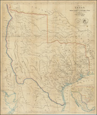
This impressive wall map shows all of Mexico, Central America and the Caribbean, with a Belgian Colony at its center, demonstrating its ideal location and good prospects for the colonization efforts of the Belgian Company of Colonization. An inset map shows the area that was the subject of the Belgian colony, it is titled "Carte du District de Santo-Thomas, Etat de Guatemala, Cede a la Compagnie Belge de Colonisation." Another inset plan shows Guatemala City along with an extensive key, it is titled "Plan General de la Ville de Guatemala."
Based upon the title of the Santo Tomas inset map, which notes that the District had been "ceded" to the Compagnie Belge de Colonisation, the most likely date of publication corresponds to the time period of the Compagnie's aggressive acts to remove the indigenous Guatemalan residents of the District beginning in March 1844, with the arrival of Major Augustin Scévola Guillaumot and the actions of Geronimo Paiz in May 1844, which re-asserted Guatemalan control over the District.
The flags and naval ensigns of various countries are also included. Probably most interesting among these are the flags of the Compagnie Belge de Colonisation (which was variation on the Guatemalan flag, turning the blue bars horizontally and using a beehive as the central motif), Hawaii, the United States of Central America, and the Republic of Texas Naval Ensign.
The map is also interesting for Texas collectors. It is one of only a very few printed maps (including the 1830 Austin map of Texas) to include the location of a very early military battle in Texas, showing the location of the Battle of Medina in 1813 an early Tejano attempt for independence from Spanish Texas and deadliest battle ever fought on Mexican soil. On the map, it is references at "Toledo defait 1813." The map also bears the naval ensign of the Republic of Texas, another great rarity.
The Belgian Company of Colonization
On January 30, 1841, a group of investors, under the patronage of King Leopold I of Belgium, received concession charters from the Commercial and Agricultural Company of the Eastern Coast of Central America (which operated under the British crown). These charters were granted by the regime of the Federal Republic of Central America from which the Republic of Guatemala was liberated under the leadership of Rafael Carrera.
On September 18, 1841, the company was formed with the aim of "creating agricultural, industrial and commercial establishments in the various states of Central America and other places" and "to establish commercial relations between these countries and Belgium". In fact, the company has a concession of 404,666 hectares of land in the district of Santo Tomás de Castilla (department of Vera-Paz), granted by the new regime of Rafael Carrera. This creation was sanctioned by royal decree on October 7 of the same year, and the Belgian State granted it an important subsidy.
In accordance with the statutes, an exploration commission was sent on November 9, 1841, in order to prepare the ground (and finalize the land transfer). After two months of travel, the schooner arrived in Guatemala, loaded with arms and gold. The statutes also provide that “after each sale of 1000 lots of land, a shipment will leave Belgium for Central America."
Conceptually the enterprise promised public and private rewards, but in fact it experienced problems on both sides of the Atlantic. In Belgium the organizers and directors—speculators and close friends of Léopold I—tried, against the wishes of his anticolonialist legislature, to acquire overseas territories using the private sector. In Guatemala the political scene was reversed. The Liberal government of the 1830s, which favored foreign investment, had been succeeded by Rafael Carrera's xenophobic Conservative ministers, although members of the Constituent Assembly with business and commercial interests championed the Belgian proposals. The company bribed prominent advocates for the enterprise, paying through a Guatemalan firm (Pullieiro, Balcárzel, and Associates) in Izabal and Santo Tomás whose public-works concessions and constructions the company promised to buy. Two Conservative members of the Assembly argued that Guatemala would suffer as badly from a future Belgian commercial monopoly at Santo Tomás as from the present British monopoly exercised from Belize. They predicted that a Belgian enclave would threaten Guatemalan sovereignty over its Caribbean coastline and the adjacent littoral province. The Assembly nevertheless approved the contract on May 4, 1842.
In March 1843, a new convoy left Belgium with a few notables and a hundred settlers, ex-prisoners, recruited by a major advertising campaign and unaware of what awaited them. The engineer Pierre Simons was a fallen pioneer of the Belgian state railways and director of the first settler community was on the schooner. He died after a few days at sea.
In May 1843, a communitarian settlement began at Santo Tomás, but the landless residents fell prey to disease, dissension, and intrigue. The colonial administration changed personnel four times. In March 1844, Major Augustin Scévola Guillaumot arrived as the new colonial director, with extraordinary powers to institute a "military regime" for order and work. He also held covert instructions to lay the foundation for a future action to separate the District of Santo Tomás from Guatemalan jurisdiction. He raised the immigrant population to 800 civilians and 48 Belgian soldiers, like himself, who were officially on leave but posted to service with the company.
Sealing off Santo Tomás as an ethnic enclave, Guillaumot fired the Indian workers, drove the native-born residents from the colony, and rejected proposals from Guatemalan and Belize merchants to establish branch outlets at Santo Tomás. He violated the company's customs exemptions by importing luxury goods duty free for sale in the interior. The commandant of Izabal, Gerónimo Paiz, entered Santo Tomás in May 1844 with a detachment of soldiers and re-established Guatemalan presence. He installed a port authority and customs director subordinate to his authority. In November, Carrera created a Permanent Commission on Santo Tomás Affairs and appointed General Manuel José Arce as corregidor. Guillaumot resigned. The settlement faltered. Many of the colonists moved inland to the capital or relocated in Belize or Honduras. The colonial population plunged to 280.
In 1847, it was clear that the venture was not a success. The colony survived without having shipped any substantial goods to Belgium. At this point, the first group of settlers was repatriated to Belgium.
In 1855, Guatemala withdrew from the Company the rights that it had acquired. Belgium was forced to stop the experiment for good. A final repatriation was organized for the settlers who wished to return. Some owners decided to stay put and continue on their own (often in Guatemala City). Thus, Guatemalan President Óscar Berger (who was in office from 2004 to 2008) is the descendant of Belgian settlers.
The Gutierrez-Magee Expedition and the Battle of Medina
The map notes "Toledo defait 1813," a reference to the Battle of Medina. Bernardo Gutiérrez de Lara was one of the earliest Tejanos to attempt to free Texas from Spain. Gutiérrez visited Washington, D.C., gaining some support for his plans. In 1812, Colonel Augustus Magee, who as a lieutenant had commanded U.S. Army troops guarding the border of the Neutral Ground and Spanish Texas, resigned his commission and formed the Republican Army of the North to aid the Gutiérrez–Magee Expedition (1812-13), a joint Mexico-US filibustering expedition against Spanish Texas during the Mexican War of Independence (1810-21). The army flew a solid emerald green flag, thought to have been introduced by Colonel Magee, who was of Scots-Irish descent.
Nacogdoches was taken by the Expedition on August 12, 1812, with little opposition, and on November 7, 1812, the Republican Army of the North marched into what is present-day Goliad, where they took the Presidio La Bahía. The Spanish Army soon confronted them, beginning a four-month siege. While at La Bahia, however, Colonel Magee died (February 6, 1813). After numerous battles and heavy losses, the Spanish lifted the siege and returned to San Antonio de Bexar.
On March 25, 1813, the Republican Army of the North left La Bahia for Bexar after receiving reinforcements. Colonel Samuel Kemper (brother of Reuben Kemper (another soldier very familiar with filibustering) replaced Magee, and Lt. Col. Reuben Ross was elected to second in command.
The Battle of Medina was fought south of San Antonio de Bexar on August 18, 1813, as part of the Mexican War of Independence against Spanish authority in Mexico. Spanish troops led by General José Joaquín de Arredondo defeated the Republican Army of the North. It was the deadliest battle in Texas history.
Rarity
The map is extremely rare. We locate a single example of the map, at the Library of Congress.
![(Mexican-Aztec Paintings) [Codex Cospi or Bologna] Aglio Mexican Antiquities. Facsimile of an Original Mexican Painting preserved in the Library of the Institute at Bologna, British M[useum]](https://storage.googleapis.com/raremaps/img/small/102339.jpg)
![[Republic of Texas] Texas](https://storage.googleapis.com/raremaps/img/small/94176.jpg)