|
||

|

|
|

|
The First Map of the Southwest Based Upon First Hand Observations
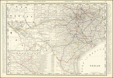
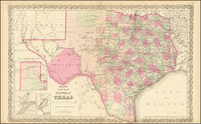
Pike's influential map of Texas and the Southwest is the first map of the Southwest to be based on firsthand exploration and is widely regarded as one of the milestones in the mapping of the American West.
Based in part on the maps of Alexander von Humboldt, which were available to Pike in Washington yet remained unpublished until a year after Pike’s map appeared, Wheat notes that the map provides a critical firsthand look at Texas and the West at the opening of the nineteenth century.
While similar to Humboldt's later map, this map provides a significant improvement in the rendering of the interior of Texas. With the exception of the lower courses of the Sabine and the Neches, which are distorted to the east, the rivers are shown quite accurately. The Brazos is, for the first time in a printed map, shown in almost its proper length and shape. However, Lake Timpanogos still appears, as do several of mythical rivers in Utah.
The legend near the title identifies key features of the area including provincial boundaries, capital cities, Spanish towns and villages, Indian villages, fortifications, springs, empty settlements, roads, and, most important for this map, the route traveled by Pike’s men in 1807. There are also many detailed notes included about local peoples, the terrain, and previous explorations by Euro-descendants.
The western expeditions of Zebulon Pike
Zebulon Pike was born in 1779 in New Jersey; his father was an officer in the Continental Army during the American Revolution. A teenage Zebulon followed in his footsteps, joining the army after being raised on a series of western outposts. One of his first assignments was to trail the French expedition under General Georges Henri Victor Collot, which was mapping the Mississippi frontier.
Following the Louisiana Purchase, President Thomas Jefferson needed to know more about the vast swath of land he had purchased, as well as extend American sovereignty into an area that already contained French, British, and Spanish trappers and traders. Additionally, he needed to create new treaties and relationships with the Indigenous peoples. To achieve these aims, Jefferson ordered several expeditions into the American West, including the Lewis and Clark expedition and what are now known as the first and second Pike expeditions.
Initially, Lieutenant Pike was charged with the command of a reconnaissance expedition to find the source of the Mississippi River. Pike’s mission left St. Louis on April 9, 1805 with orders to expel fur traders operating illegally within US borders, to establish cordial relations with several powerful tribes, and to survey the Mississippi and its tributaries. They set off upstream and reached the convergence of the Mississippi and the Minnesota Rivers in September. There, Pike purchased land from the Dakota people which would become Fort Snelling. They camped at the mouth of the Swan River and then continued north on the frozen waterway to contact British North West Company fur posts.
The farthest north they reached was Leech Lake. Pike told the traders there that they were now under US jurisdiction and he struck the British flag from the site. He also met with Ojibwe leaders. Pike thought that the nearby Upper Red Cedar Lake might be the upper source of the Mississippi and conducted latitude readings there. The American travelers headed south at the end of February 1806. They returned to St Louis on April 20, the first of the government’s western expeditions to return.
Only ten weeks later, Pike was off again, this time to the southwest. He was to map the headwaters of the Arkansas and Red Rivers, as well as to survey the southwestern Louisiana Territory. Pike and his men left on July 15, 1806. By November, they were in what is today Colorado. They attempted to climb the tallest elevation they had seen thus far; although he never scaled it, the mountain is now known as Pike’s Peak, one of the most famous geographic features in the Continental United States.
From Colorado the group turned south, which brought them into Spanish territory. They were seized by Spanish soldiers and brought to Santa Fe to be interrogated and detained. From there, they journeyed to Chihuahua state in Mexico, where they stayed for several months. Pike’s papers were seized. However, he was allowed to socialize with the officers and learned much about the state of affairs and politics in what was then New Spain. He took new notes and smuggled these out in the gun barrels of his men. The US and Spain were at peace during this time; therefore, Pike and his men were escorted from Spanish holdings via San Antonio to the American border in early July.
Pike would go on to serve in the War of 1812, where he was promoted to the rank of brigadier general. He died fighting at the Battle of York in April 1813.
The seizure of his journals did not seem to faze Pike, who wrote a stirring account of his adventures, with the part on the second expedition drawn mainly from memory. This was published in 1810 as An Account Of Expeditions To The Sources Of The Mississippi, And Through The Western Parts Of Louisiana. The narrative proved popular and was quickly released in Dutch, French, and German editions. It was a must-read for explorers and settlers of the American West until well into the twentieth century.
Pike provided some of the first descriptions of the American West—especially of Texas, Colorado, and New Mexico—to the reading public. For example, the section on Texas is the first to describe the area in detail in English. His is one of the most important books on western exploration and one of the pillars of Western Americana.
Pike also produced several maps to accompany the account which are very influential in the history of American cartography. These were the first maps of the Louisiana Territory to be based on first-hand observations. His map of New Spain was based on Humboldt’s, although the latter was not published until a year later. All of Pike’s maps were foundational for later cartographers and are some of the earliest western maps produced in the still-growing United States.
![[ Southern Railroads ] Railroad Map of the Southern States Shewing the Southern & Southwestern Railway Connections With Philadelphia. 1862 . . . Prepared by Thomas Kimber Jr., Chairman of the Committee on Inland Transportation of the Board of Trade of Philadelphia](https://storage.googleapis.com/raremaps/img/small/103211.jpg)
![(Pacific Railroad Surveys) Reports of Explorations and Surveys, to Ascertain the Most Practicable and Economical Route for a Railroad from the Mississippi River to the Pacific Ocean [with:] Map of the Territory of the United States from the Mississippi to the Pacific Ocean](https://storage.googleapis.com/raremaps/img/small/98651.jpg)
![[ Hungarian Traveler In the California and the West with a Comanche and Wichita to Hungarian vocabulary ] Levelei Éjszakamerikából -- Tizenkét eredeti rajzok után készült kő- és egynéhány fametszettel. Közli Prépost István (Letters from North America)](https://storage.googleapis.com/raremaps/img/small/98502.jpg)