|
||

|

|
|

|
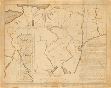
Detailed electric railway map, promoting lines of Dell's Electric Railway.
The map covers the areas from Lake Erie to Louisville and South Bend to Pittsburgh. Indianapolis, Detroit, Cleveland, Wheeling WV, Columbus, Cincinnati, Fort Wayne, and Toledo are other major hubs on the map.
Solid lines represent active lines, with dashed lines being under construction.
The map illustrates Dell's remarkable interurban rail network linking major urban centers as well as smaller independent lines serving small rural communities. By 1910, this system was largely complete and effectively served a huge portion of the population. At the end of the 19th century nearly 80% of Midwestern residents lived within 5 miles of a railway.
Rarity
The map is apparently rare. No copies listed in OCLC. We note at least 1 institutional example (Cornell).
![(Early Philadelphia Architectural Drawings) Plan of the ceiling of St. Andrews Church [with two additional drawings on another sheet]](https://storage.googleapis.com/raremaps/img/small/90443.jpg)