The item illustrated and described below is sold, but we
have another example in stock. To view the example which
is currently being offered for sale, click the
"View Details" button below.


|
||

|

|
|

|
Stock# 73164
Description
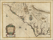
Nice example of Ogilby's edition of John Smith's map of the Virginia & Chesapeake region.
The map is based upon the earlier maps by Hondius and Blaeu, a bit smaller, but with 3 large cartouches, one of which includes fascinating indigenous animals, including a llama and horned long haired sheep. Smith's map of the Chesapeake region was the basic prototype of all regional maps until Augustine Herman's exceedingly rare 4 sheet map published in London in 1673. Tooley notes that the map derives from the first state of the Smith map, and therefore lacks the longitude lines added in later states.
An attractive full color example of this increasingly scarce map.
Reference
Burden, P.D. #412; Tooley, R.V. (Amer) pp.168-169, pl.76; Goss, J. (N. Amer) #38.
![[Jefferson's Notes on the State of Virginia] Observations sur la Virginie [with the map:] A Map of the country between Albemarle Sound, and Lake Erie, comprehending the whole of Virginia, Maryland, Delaware, and Pensylvania, with parts of several other of the United States of America. Engraved for the Notes on Virginia.](https://storage.googleapis.com/raremaps/img/small/51828.jpg)

![[ First Map of Maryland ] Nova Terrae Mariae Tabula](https://storage.googleapis.com/raremaps/img/small/98196.jpg)