|
||

|

|
|

|
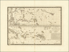
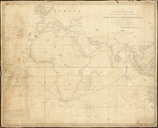
Rare Late Edition of Jansson's Map of the Indian Ocean with Updated Information in Australia
Important and rare second state of Jansson’s important sea chart of the Indian Ocean, showing early Dutch encounters with Australia with the addition of Tasman’s voyages.
The most interesting changes to this version of the map can be found in Australia, which has a complete northern coastline. The first state had none of the toponyms along the northern coast and only showed the encounters of Dutch ships with the Cape York Peninsula and the western shore. This state connects the names stemming from Tasman’s second voyage in 1644 in the north with these earlier shipwrecks and chance encounters to the west. Additionally, van Diemen’s land, spotted by Tasman on his first voyage (1642-3) is in the south.
The chart was updated in 1664 for Jansson's Atlas Maior in a commercially unsuccessful attempt to compete with Joan Blaeu's Atlas Maior. Jansson's Atlas Maior is of the greatest rarity. The last example offered at auction was in the Sotheby's auction in 2005-2006 of the illustrious Lord Wardington collection of atlases.
The chart extends from Cape Horn to a nascent outline of what is now Australia. From south to north it stretches from the empty ocean at 50 degrees south latitude to Japan and Korea. Japan is shown in a horizontal position, a typical representation of the islands during the seventeenth century. Korea is described as an island (see below).
In the Indian Ocean, Madagascar curves slightly to the east. The sea is dotted with islands, sand banks and bars, and reefs.
Rhumb lines criss-cross the watery spaces, suggesting the vast volumes of trade that sailed the Indian Ocean in the seventeenth century. Two compass roses are set in the lower third of the chart. Between them is the title cartouche, which is framed by two indigenous peoples with bows and arrows (left) and two Asian traders (right). Five putti perch on the decorative cartouche housing the scale in the upper left corner.
The Dutch Golden Age and the expansion of trade
The Dutch experienced what is referred to by historians as a Golden Age in the seventeenth century, although this was achieved via investment and participation in the human slave trade. The term can apply to the extraordinary volume and quality of Dutch art in this period, to the prominence of Dutch traders in international commerce and finance, as well as to the dominance of Dutch geographers and publishers, who led the European map and atlas trade throughout the century.
The focus on the Indian Ocean in this chart is prescient, as trade with the Indian subcontinent and the East Indies was a central focus for the Dutch when the chart was made. The Moluccas, just west of Papua, were of importance for they were the vaunted Spice Islands, originally the only source in the world for nutmeg, mace, and cloves. The Portuguese were the first Europeans to gain power in the East Indies, trading for spices in the Moluccas and controlling the spice market in Europe.
The Dutch wanted in on the lucrative trade, but they also had to contend with the Portuguese. The first Dutch expedition, led by Cornelis de Houtman in 1595, avoided India, the Strait of Malacca, and the Moluccas—Portuguese strongholds—in favor of the Sunda Strait. The Dutch set up their trade centers on the island of Java, at Bantam and, later, Batavia; both are labeled here. After Houtman, the second Dutch expedition (1598-1600) quickly set sail for the East Indies. It was followed by five others. In 1602, the most powerful of these merchants and the Dutch government, the States General, created the Dutch East India Company (VOC), a monopoly to control the East Indies trade.
Dutch exploration south of the East Indies
Unfinished coastlines on the islands east of Java suggest the unknown lands still to be encountered by Europeans. New Guinea is a long thin island that extends nearly into the eastern edge of the chart. It is very close to another coastline that we now know as the Cape York Peninsula in Australia. Although Torres had sailed through the strait now named for him in 1606, the Spanish government suppressed news of the voyage.
Janssonius based this portion of the chart on an earlier chart of the East Indies by Hondius, first published in 1636, which in turn was based on a slightly earlier chart by Blaeu. Like Hondius before him, Janssonius does not quite connect New Guinea and the coast to the south. There is a note, outlined in manuscript hand here, that says that part of the island, known as “Terra d’os Papous” was named by Jacob le Maire. Le Maire was part of a very important voyage from 1615 to 1617. Not only did he and his fellow Willem Schouten (whose name is on an island off the coast of Papous) circumnavigate the world and give many Pacific islands Dutch names, they also passed round Cape Horn via a strait that now bears Le Maire’s name. As the Strait of Magellan had been under a VOC monopoly, Schouten and Le Maire’s voyage provided Dutch traders and those of other nationalities freer access to the Pacific.
Like the Spanish, the Dutch also kept geographic knowledge secret. However, they employed official hydrographers who simultaneously ran commercial print shops, thus providing a channel for geographic knowledge to reach a wider public. However, some information was successfully suppressed; for example, the results of Tasman’s voyages in Australia were not included in the first state and were only added here in 1680.
An early outline of Australia
Janssonius includes a rough outline of Australia, or New Holland and Terre del Zur as written here, chronicling the Dutch voyages that tentatively sailed along the western coast of the continent. The information for portions of the coasts in New Guinea and northern Queensland, Australia come from the voyage of the Dutch vessel Duyfken in 1605-06. Under the command of Willem Janszoon, the Duyfken explored the eastern shore of the Gulf of Carpentaria, just below the Cape York Peninsula, a venture which was famously the first recorded European contact with Australia.
The toponyms on the northern coast stem from the work of Abel Tasman. The VOC wanted to know if the reports of Australian coastal encounters indicated the discovery of the southern continent or were just smaller islands. To answer this question, Tasman sailed from west to east in 1642-3, from the East Indies into the Indian Ocean, along the southern coast of Van Diemen’s Land (Tasmania), out to New Zealand, then north through Tonga and the Solomons and New Guinea. Here, this first voyage is represented by the Van Diemen’s Land coast. In 1644, Tasman took to the seas again, circling the East Indies and coasting from the Cape York Peninsula west along the entirety of the northern coast of Australia.
Tasman had sailed prior to the creation of the first state of this map for the Atlas Maritimus in 1650. However, news of the voyages’ findings trickled only slowly into print and onto maps in the mid-to-late seventeenth century. The VOC was not particularly impressed with Tasman’s findings and they did not promote his voyages.
Further west on this map is G.F. de Wits, which refers to the 1628 voyage of Gerrit Fredericsz De Wit to the western coast of Australia. The largest label is t’Landt vam d’Eendracht 1616. The Eendracht was blown off course en route to the East Indies in that year. It was commanded by Dirk Hartog and Hartog’s landing was the first recorded European landing on the western coast of Australia. It is marked here as well, Dirk Hartogs ree. The crew commemorated their discovery by erecting a post with a pewter dish inscribed with their ship’s information—the earliest physical record that historians have of any European landing in Australia.
Slightly west, out to sea, is a tiny geographic feature called Trial. These refer to the rocks struck in the dead of night by the English ship Trial. The survivors of the wreck managed to sail in two small craft to Batavia in July 1622 and report the dangerous, but hard to locate, obstructions. These details of the Duyfken, Eendracht, and Trial were all included in the earlier Hondius chart.
Farther south, Janssonius has also included other Dutch voyages. Houtmans Abrolhos and I. de Edells landt det. 1619 refer to the same voyage. Jacob d’Edel, in the Amsterdam, along with Frederik de Houtman in the Dordrecht came within sight of the western coast and called the stretch of land d’Edelsland. The Houtmans Abrolhos are an archipelago, as shown here, named for the navigator who sighted them, or at least it was Houtman who reported the islands to the VOC. The name Houtmans Abrolhos, as used on this chart, was first used in Hessel Gerritszoon’s 1627 chart Caert van't Landt van d'Eendracht. Also included on Gerritszoon’s chart is the shoal sighted by and named for the Tortelduyf, which is labeled here.
Along the southern coast, ‘t Landt vande Leeuwin det 1622 is named for the Leeuwin, whose crew charted some of the southwest coastline in 1622. ‘t Landt van P. Nuyts 26 Jan 1627 is named for Pieter Nuyts, a Dutch navigator who commanded the Gulden Zeepaert along the southern coast in 1627.
Interestingly, though, Jansson has not included several details. For example, there is no mention of the well-known wreck of the Batavia on the Houtman Abrolhos in 1629.
Rarity
The first state of the map was included in the Atlas Maritimus, widely considered the first true sea atlas; it was the fifth volume of Janssonius’ Atlas Novus, first published in 1650.
This state of the map is considerably rarer than the first. OCLC lists only six institutional examples of the second state: National Library of Singapore, State Library of Queensland, National Library of Australia, State Library of New South Wales, State Library of Victoria, and the Alexander Turnbull Library at that National Library of New Zealand.
This is the first time we have featured the second state in the past 25 years.
The sequence of events and maps that led California to be portrayed as an island are much clearer than another famous peninsula-turned-island, Korea. Korea is briefly mentioned in the thirteenth century by Marco Polo as Cauli (Kauli), but otherwise Korea was not described again for European audiences until the late-sixteenth century.
As with Japan and China, most of the earliest bits of information about Korea came from the Jesuits sending letters sent back from East Asia. However, the Jesuits were not actually stationed in Korea; they could only glean impressions from Chinese and Japanese sources. For example, Father Luis Frois wrote of Korea in the context of a war with Japan in 1578. Frois explained that Korea was separated from Japan by a sliver of sea. It had previously been understood to be an island, he explained, but was now known to be a peninsula. However, why Korea was thought to be an island, by who, and how it was found to be a peninsula was not shared with Frois’ curious readers back in Europe.
The first known European to visit Korea was also a Jesuit, Father Gregorio des Cespedes. He accompanied Japanese troops during another war with Korea in 1592. The territory did not agree with Cespedes, who found it bitingly cold. He did not mention anything about the Korean peoples or their geography.
Travel writers, those who actually traveled and those who were more drawn to the armchair voyage, also wrote about Korea. Jan Huygen van Linschoten spent several years in Goa, India, where he had access to Spanish and Portuguese sources. In his Itinerario, first published in German and English in 1598, he suggests Korea is a large island called Core. Richard Hakluyt read the Jesuit letters, which were republished in sets of annual letters. In the second edition of his Principal Navigations (1599), Hakluyt included the information from Frois and Cespedes, scant as it was.
Given the relative dearth of source material, it is not surprising that early maps by Münster, Mercator and Ortelius omitted Korea entirely. The first map to show Korea was Orbis Terrarum Typus de Integro Multis in Locis Emendatus by Petrus Plancius (1594). It included “Corea” as a long, skinny peninsula barely attached to the northeast corner of China. Edward Wright, in the map accompanying Hakluyt’s Principal Navigations, adopted a similar depiction of Korea, as did other mapmakers from the 1590s onward.
Interestingly, the map that accompanied Linschoten’s Itinerario, by Arnold Floris van Langren, shows Korea as a large, round island. However, no other mapmaker is known to have followed this example. Another early island depiction that was widely adopted was that of Luis Teixeira in the 1595 edition of Ortelius’ Theatrum Orbis Terrarum. The long, thin island was used by several cartographers, including Jodocus Hondius, in the seventeenth century. Blaeu also used the Teixeira model before creating a new Korea in later maps that looked like a bat hanging from China, separated from the mainland by the thinnest of waterways.
Confusion over island vs. peninsula continued across seventeenth-century maps. For example, John Speed includes three separate versions of Korea across four maps in his A Prospect of the Most Famous Parts of the World (1626). It is shown on the Teixeira island model, as a thin peninsula, and as a blunt island. These various hypotheses as to the shape of Korea continued to coexist for decades.
Finally, in the 1650s, Father Martino Martini gathered more information and created a new map of Korea. In China from 1642 to 1651, Martini spent a good deal of time with Chinese maps and their makers. Thus, he created new maps showing Korea as a thicker, nearly rectangular peninsula in Bellum Tartaricum (1654) and the Atlas Sinensis (1655).
Also in the 1650s, a Dutch sailor named Hendrick Hamel was shipwrecked on Jeju, an island near southern Korea. Hamel and his fellow survivors would spend thirteen years in Korea, escaping to Nagasaki in 1666. He wrote about the ordeal in a journal that was published in 1668. Although it lacked maps, the ample descriptions confirmed that Korea gave a detailed, first-hand view of Korean geography and culture.
Nevertheless, several maps were published in the early eighteenth-century showing Korea as an island. The island myth, which most likely stemmed from a misreading of Japanese and Chinese maps by early Jesuits, proved to be quite entrenched. Only in 1735 did Jean Baptiste Bourguignon d’Anville produce a map with a roughly accurate outline of the peninsula and a relatively detailed interior.
Jan Janssonius (also known as Johann or Jan Jansson or Janszoon) (1588-1664) was a renowned geographer and publisher of the seventeenth century, when the Dutch dominated map publishing in Europe. Born in Arnhem, Jan was first exposed to the trade via his father, who was also a bookseller and publisher. In 1612, Jan married the daughter of Jodocus Hondius, who was also a prominent mapmaker and seller. Jonssonius’ first maps date from 1616.
In the 1630s, Janssonius worked with his brother-in-law, Henricus Hondius. Their most successful venture was to reissue the Mercator-Hondius atlas. Jodocus Hondius had acquired the plates to the Mercator atlas, first published in 1595, and added 36 additional maps. After Hondius died in 1612, Henricus took over publication; Janssonius joined the venture in 1633. Eventually, the atlas was renamed the Atlas Novus and then the Atlas Major, by which time it had expanded to eleven volumes. Janssonius is also well known for his volume of English county maps, published in 1646.
Janssonius died in Amsterdam in 1664. His son-in-law, Johannes van Waesbergen, took over his business. Eventually, many of Janssonius’ plates were sold to Gerard Valck and Pieter Schenk, who added their names and continued to reissue the maps.