


|
||

|

|
|

|
Annotated With Detailed From Strabo!
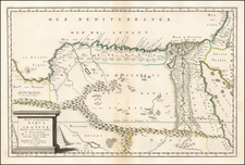
Extensively hand annotated example of Sylvanus' map of Egypt, Red Sea, Nile, and a part of Eastern Libya, extending west to Benghazi and the Gulf of Sirte.
The map includes annotations on both sides of the map in a a contemporary hand, with extensive references from the work of Strabo (64 BC -21 CE), a Greek geographer and historian whose Geography is the only extant work covering the whole range of peoples and countries known to both Greeks and Romans during the reign of Augustus (27 BCE–14 CE).
The owner of this map evidently utilized Strabo's text as a means of annotating the work of Ptolemy, perhaps as an early comparative analysis of the two ancient geographers.
A number of copies of Strabo's manuscript survived throughout the Byzantine Empire. It first appeared in Western Europe in Rome as a Latin translation issued around 1469. The first Greek edition was published in 1516 in Venice. Although Strabo cited the classical Greek astronomers Eratosthenes and Hipparchus, acknowledging their astronomical and mathematical efforts covering geography, he claimed that a descriptive approach was more practical, such that his works were designed for statesmen who were more anthropologically than numerically concerned with the character of countries and regions.
Sylvanus's map is one of the earliest obtainable maps to show a significant portion of the African continent. It provides a marvelously detailed look at the known parts of Africa based on Ptolemy's work, only 23 years after Bartolomeu Dias's rounding of the Cape of Good Hope.
The map appeared in Sylvanus' Claudii Ptholemaei Alexandrini liber Geographicae . . ., publish in Venice in 1511. The Sylvanus edition of Ptolemy is one of the earliest to include maps with modern geographical updates. The rich topographical style of the map is a marked deviation from earlier Ptolemy maps of the region. Sylvanus' work was also a landmark in the history of printed maps, being the first maps printed in two colors.
Sylvanus printed each of his maps using two plates, with each of the map sheets in the work printed on both sides, meaning that there are halves of two different maps on the back side of this example of the map. As a result, Sylvanus' maps are very rare on the market and certain maps virtually never appear on the market, where they appeared on the verso of maps which were more heavily sought after by collectors.
Bernardus Sylvanus (Bernardo Silvano) was born around 1465 in Eboli, a small agricultural town near Salerno in southern Italy. He began studying Ptolemy around 1490, when he was living in Naples. At this time he ran a print shop or studio, producing maps and codices. It was here that he produced his first edition of Ptolemy’s Geographia in 1490, which he dedicated to Andrea Matteo Acquaviva, the third Duke of Atri. For this edition Sylvanus used coordinates and text from Jacopo d’Angelo’s translation, and copied the maps from a Roman printed edition of either 1478 or 1490 (both printed from the same plates). Sylvanus’ 1511 Venice edition of the Geographia built on his prior work, but was groundbreaking in several regards. It was the only edition to add modern updates directly into Ptolemy’s maps, the only edition at the time to print maps on both sides of the leaf, the first edition printed in two colors, and the first Italian edition to use woodblocks. Nothing is known of Sylvanus’ life after the publication of this edition.
![[Medieval Map of the Holy Land]](https://storage.googleapis.com/raremaps/img/small/94822.jpg)
![Africae II Tab [Shows Malta, Sicily and Sardiia]](https://storage.googleapis.com/raremaps/img/small/78022.jpg)
