


|
||

|

|
|

|
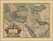
Fine Map of the Ottoman Empire from the Mercator-Hondius Atlas
Striking example of this map of the Ottoman Empire, showing their territories in the Balkans, Anatolia, the Levant, the Arabian Peninsula, and North Africa.
It was published by Henricus Hondius in his Atlas sive Cosmographicae Meditationes de Fabrica Mundi et Fabricati figura, which translates to the “atlas or cosmographical meditations on the fabric of the world and the figure of the fabric.” This was the atlas begun by the famous Gerard Mercator and published by the Hondius firm throughout the seventeenth century.
The border of the Ottoman Empire is marked with a dotted line, demarcating one of the largest land empires in history. Cities and towns are labeled and marked with the characteristic small building symbol that was used throughout the atlas. Mountains and dunes are included, especially on the Arabian Peninsula. Notes indicate extra information about the Caspian Sea, Black Sea, and kingdoms that ring the Ottomans.
A handsome strapwork cartouche holds the title and scale in the lower left corner. At the top is a portrait of Sultan Mahumet Turcorum Imperat. This refers to Mehmed III, sultan from 1595-1603. Mehmed III is known for the fratricide of his nineteenth brothers, the war with Austria-Hungary, the Jelali Revolts, and the reception of Queen Elizabeth I’s envoy in 1599.
This map first appeared in the atlas in 1606, an additional plate added by Jodocus Hondius. It continued to appear there until the French edition of 1639-44.
Jodocus Hondius the Elder (1563-1612), or Joost de Hondt, was one of the most prominent geographers and engravers of his time. His work did much to establish Amsterdam as the center of cartographic publishing in the seventeenth century. Born in Wakken but raised in Ghent, the young Jodocus worked as an engraver, instrument maker, and globe maker.
Hondius moved to London in 1584, fleeing religious persecution in Flanders. There, he worked for Richard Hakluyt and Edward Wright, among others. Hondius also engraved the globe gores for Emery Molyneux’s pair of globes in 1592; Wright plotted the coastlines. His engraving and nautical painting skills introduced him to an elite group of geographic knowledge seekers and producers, including the navigators Drake, Thomas Cavendish, and Walter Raleigh, as well as engravers like Theodor De Bry and Augustine Ryther. This network gave Hondius access to manuscript charts and descriptions which he then translated into engraved maps.
In 1593 Hondius returned to Amsterdam, where he lived for the rest of his life. Hondius worked in partnership with Cornelis Claesz, a publisher, and maintained his ties to contacts in Europe and England. For example, from 1605 to 1610, Hondius engraved the plates for John Speed’s Theatre of the Empire of Great Britaine.
One of Hondius’ most successful commercial ventures was the reprinting of Mercator’s atlas. When he acquired the Mercator plates, he added 36 maps, many engraved by him, and released the atlas under Mercator’s name, helping to solidify Mercator’s reputation posthumously. Hondius died in 1612, at only 48 years of age, after which time his son of the same name and another son, Henricus, took over the business, including the reissuing of the Mercator atlas. After 1633, Hondius the Elder’s son-in-law, Johannes Janssonius, was also listed as a co-publisher for the atlas.

![Geografia degli Ebrei o Divisione de' Popoli secondo il Sistema Biblico [Geography of the Jews or Division of Peoples according to the Biblical System]](https://storage.googleapis.com/raremaps/img/small/87430.jpg)
![[ Turkish Empire ] Turcicum Imperium. Turckiche Reich. Concordia res parvae crescunt Discordia maximae dilabuntur](https://storage.googleapis.com/raremaps/img/small/68352.jpg)
![[ Turkish Empire ] Imperium Turcicum Complectens Europae, Asiae, et Africae, Arabiae que Regiones ac Provincias Plurimas Industria et Labore . . .](https://storage.googleapis.com/raremaps/img/small/104260.jpg)
![Asia Minoris Iacobi Cantelli Vineolensis . . . 1686 [Shows Cyprus]](https://storage.googleapis.com/raremaps/img/small/37656.jpg)