The item illustrated and described below is sold, but we
have another example in stock. To view the example which
is currently being offered for sale, click the
"View Details" button below.


|
||

|

|
|

|
Stock# 72693
Description
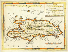
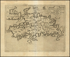
One of the Earliest Obtainable Regional Maps of Hispaniola.
Cornelis Wytfliet's double-page engraved map of the Hispaniola, one of the earliest to focus on the island.
Important early map of the Hispaniola (which today includes Haiti and the Dominican Republic), from Cornelis Wytfliet's Descriptionis Ptolemaicae Augmentum, the first atlas to focus on the mapping of the New World.
As noted by Burden:
In 1597 Cornelis van Wytfliet published his Augmentum to Ptolemy's Geography. This is true in as much as it covers all the Americas, a part of the world unknown to the latter; however, no other connection between them exists. Dedicated to Philip III of Spain it is a history of the New World to date, recording its discovery, natural history etc. For the book Wytfliet had engraved nineteen maps, by whom we do not know, one of the world and eighteen regional maps of the Americas. . . As such this book can be truly called the first atlas of America. It was an immediate success and ran to several editions.
An essential map for regional collectors.
Cornelis van Wytfliet Biography
Cornelius de Wytfliet (ca.1550-ca. 1597) was a Flemish cartographer most famous for his Descriptionis Ptolemaicae Augmentum. The work was published in Louvain, Belgium, and had nineteen maps of the Americas.
![Cuba Insula [with] Hispaniola Insula [with] Insula Jamaica [with] Ins. S. Ioannis [with] I.S. Margareta Cum Confiniis](https://storage.googleapis.com/raremaps/img/small/95802.jpg)