


|
||

|

|
|

|
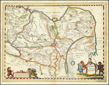
Detailed regional map, extending from the Red Sea to the Indus Riverand from the Caspian to the Indian Ocean. A number of interesting regional names appear, including Koondooz, Bokhara, Cabool, Khiva, Beloochistan, Kirman, Laristan, Irak Ajemi, Ghilan Mazanderan, Toorkmania, Khorassan, Louristan, Koordis, Bagdad, Algezira, Irak Arabi, Khuzistan, Diarbekir, Karamania, Room or Siva, Arzeroom and others. Shows early roads, towns, rivers, etc. Includes decorative embellishments above the map and in the border. G.F. Cruchley was a mapseller and globemaker on Fleet Street in London in the mid-19th Century. His World Atlas, first published in 1854, was very unique for the period, employing vivid imagery and a striking print style, along with very distinctive coloring. Maps from his world atlas are relatively scarce on the market.
![Persia [shows Armenia]](https://storage.googleapis.com/raremaps/img/small/72526.jpg)
![[Ottoman-Turkish Map of the Middle East]](https://storage.googleapis.com/raremaps/img/small/81188.jpg)