|
||

|

|
|

|
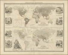
Terre du St. Esprit and the Chinese Discovery of America
Handsome example of this rare, separately-published Lyonnaise world map, dedicated to Lyon City Intendent Bertrand Rene Pallu.
Bailleul's map is a fascinating amalgam of speculative cartography, modern discoveries and brilliant images, with an especial focus on astronomical theories. Bailleul has made his best efforts to incorporate tantalizing historical accounts of early speculative discoveries with the newest data.
In the southern hemisphere, he combines rumors of the British encounter with the east coast of Australia with sixteenth-century reports of Pedro Ferdinand de Quiros. In the northern hemisphere, the great French debate around the Sea of the West and the Northwest Passage is depicted, while also incorporating prominent contemporary theories on the Chinese discovery of America long before Columbus.
Bailleul surrounds his map with modern astronomical images. A set of celestial hemispheres appear at center, with additional circles illustrating theories of the solar system by Ptolemy, Copernicus, Brahe, and Descartes, the surface of the sun and moon, and lunar and solar solstices and eclipses. Filling the extra space are vignettes of gods at work in intellectual pursuits, as well as the trope of the Four Continents—Europe, Asia, America, and Africa—as women.
The western hemisphere shows the vast Pacific dotted with islands. In the far north, tentative lines trace an outline of Alaska and several inland passages, seas, and lakes. The map references Russian discoveries in 1741 for this area. Two expeditions led by Vitus Behring (1728-30, 1733-43) explored Kamchatka and what is now Alaska, charting the strait between them and leading mapmakers to alter their visions of the North Pacific.
For the Pacific Northwest, Balleiul seems to have consulted the series of maps, including their landmark, and controversial, 1752 map, made by Philippe Buache and Joseph-Nicolas De L’Isle which included a Sea of the West and various lakes stretching nearly to Hudson’s Bay. The present map is a late example of the Sea of the West, which had first appeared on charts published by Johann Baptiste Nolin in ca. 1700, but had quickly disappeared thereafter. Although Guillaume De L’Isle never published a map showing the sea, he had postulated that it could exist, and that it might connect to a Northwest Passage through New France, not through English territory farther north. De L’Isle’s son-in-law, Buache, revived the idea.
Near the Sea of the West is the label, “Foussang des Chinois.” This note stems from the work of French Orientalist Le Guignes, who hypothesized that the Chinese arrived in the New World over a millennium before the Europeans in his 1761 work, Recherches sur les Navigations des Chinois du Cote de l'Amerique, et sur quelques Peuples situés a l'extremite orientale de l"asie. Le Guignes was named a fellow of the Royal Society of London in 1752 and his work was well known across Enlightenment Europe and integrated into the maps of Buache.
The eastern hemisphere also has several notable features. In the South Atlantic are a series of dots that represent icebergs. A nearby note explains that these were sighted in 1738 and 1739. Jean-Baptiste Charles Bouvet de Lozier was sent to search for the southern continent by the French East India Company. He crisscrossed the South Atlantic in 1738-9 and found a small island, which is named for him, as well as ample floating ice. However, he mislabeled the coordinates and therefore the island had to be rediscovered in 1808.
Perhaps the most interesting geography is that of Australia. The west coast is labelled according to Dutch encounters with the continent in the early seventeenth century. The east coast is suggestively filled in, creating a large landmass that includes New Guinea, Van Diemen’s Land, and Terre du St. Esprit.
In the north of Australia is Carpenterie, so named in 1623 by Jan Cartensz after Peiter de Carpentier, the VOC governor of the East Indies at that time. Farther west and south is Terre d’Endracht ou de la Concorde. The Endracht was the second recorded European ship to contact Australia (1616). In the southwest is Terre de Leuvin, named for the Leeuwin, whose crew charted some of the southwest coastline in 1622. Terre de Nuits is named for Pieter Nuyts, a Dutch navigator who commanded the Gulden Zeepaert along the southern coast in 1627.
In the title banner running along the top of the map is a dedication to Bertand Rene Pallu (1692-1758). Pallu served as Intendant of Lyon from July 1738 to April 1750.
Along the bottom border are four women sitting with animals. These are meant to represent the continents. Europe is at left in armor and a cross; a white horse lays behind her. Asia burns incense and holds a scepter topped with a crescent moon, a sign of Islam, while a camel looks on. Africa holds a bow and arrow and gazes back at an elephant. America, in feathers and holding a spear, is guarded by an alligator. Representing the continents in this way was popular in the eighteenth century, in maps as well as in paintings.
Quiros and Espiritu Santo
The map adopts a particular and somewhat peculiar configuration for Australia that includes a prospective eastern coastline which extends all the way to 180°E. Two rivers flow to that far shore, the Jordan and the St. Salvador.
These rivers are part of Terre du St. Esprit. This toponym connects the speculative coastline to the voyages of Pedro Ferdinand de Quiros at the turn of the seventeenth century. Quiros was a skilled pilot who accompanied Alvaro de Mendaña on his second voyage to the Solomons in 1595-6 (the first voyage took place in 1567-9).
After returning to Spain, Quiros convinced authorities that he could find Terra Australis, the southern continent, if they gave him ships and supplies. He set out in 1605 and eventually landed in Vanuatu. He mistook one of the islands for the fabled continent and called it Austrialia de Espiritu Santo. The largest island in the chain is still called Espiritu Santo today.
Quiros intended to set up a colony on the supposed continent. He performed a series of elaborate possession rituals and founded a city he called Nueba Hierusalem. The “city” was nestled between two rivers which Quiros called the Jordan and the San Salvador (likely today’s Jordan and Vitthié Rivers). However, his crew forced him to leave. Quiros returned to Mexico, but his second-in-command sailed west, through the strait now bearing his name. Due to state secrecy, however, the strait remained largely unknown until the 1760s.
Upon his return, Quiros revved up his campaign, lobbying once again for a voyage to return to his supposed southern continent. To gain support, Quiros wrote at least fifty memorials to advertise his successes and lay out his plans. Fourteen of these were printed between 1607 and 1614.
The most widely circulated was the Eighth Memorial. In it, he describes Austrialia de Espiritu Santo to be as wide as Europe, Asia Minor, the Caspian Sea, and Persia combined, “in its outline it quarters the entire Globe.” Printed in Madrid in 1608 and Seville in 1609, the Eighth Memorial was reprinted in 1612 by Dutch cartographer Hessel Gerritsz in his Detectio Freti Hudson.
Quiros’ discoveries remained tantalizing and would be revived by geographers for the next two centuries. They were part of the Abbe de Paulmier’s 1664 plan to convert the citizens of the Southern Continent. In the mid-1740s, in his reissue of Harris’ Navigantium atque Itinerantium Bibliotheca, John Campbell explained that it was likely that New Guinea and Van Diemen’s Land were all disparate parts of a large Terra Australis that connected to New Holland. His main source to back up this theory was Quiros’ memorials.
Quiros also featured in other prominent voyage collections of the mid-eighteenth century, namely Charles de Brosses’ Histoire des Navigations aux Terres Australes (Paris: Durand, 1756) and Alexander Dalrymple’s An Historical collection of the several voyages and discoveries in the South Pacific Ocean (London, 1769-71).
A hypothetical eastern coastline for Australia
Cartographically, there was variation in the placement of a hypothetical eastern coastline that included Espiritu Santo. One of the earliest maps to show this depiction seems to have been Guillaume Delisle’s 1714 map of the southern hemisphere. The map shows Espiritu Santo with the Jordan and San Salvador rivers at roughly 185°E (from an Atlantic prime meridian), but it is not connected to New Holland. Others also adopted the idea of an Australian continent stretching to Espiritu Santo, including Richard Cushee in his 38 cm. diameter terrestrial globe of 1731.
The idea of a hypothetical eastern coast, evident in the famed Bonaparte Tasman map, was revived in the 1740s and 1750s. One of the world maps in Campbell’s collection, by Emmanuel Bowen, shows T. de St. Espirit at 150°E (Greenwich meridian) as part of a suggested eastern coastline for Australia.
In 1753, Bellin connected Van Diemen’s Land to Espiritu Santo (145°E, Paris meridian), but added a note explaining the link as unproven. Robert de Vaugondy’s map of 1756 also connects the two into a large continent with New Holland (Espiritu Santo at 170°E, with an Atlantic meridian). Interestingly, the latter map was included in De Brosses’ voyage collection, wherein De Brosses expressed his belief that Espiritu Santo was insular.
The most extreme example of the connection of New Holland and Espiritu Santo was by Philippe Buache. In a 1755 update of his father-in-law’s world map of 1720, Buache connected the western Dutch discoveries, Van Diemen’s Land, Carpentaria, New Guinea, and Espiritu Santo, which was located at 180°E (Ferro meridian).
The hypothetical coastline was revived again in the early 1770s, as with this map, possibly when rumors of the findings of the first Cook expedition began to swirl upon the Endeavour’s return to England in 1771. Cook was the first European to contact the eastern shore of Australia, landing at Botany Bay and then sailing north, where he was nearly wrecked on the Great Barrier Reef.
In a 1771 world map, Thomas Kitchin includes dashed lines connecting New Guinea, New Holland, Van Diemen’s Land, and Espiritu Santo. A ca. 1772 map by Desnos has a similar outline to the one shown on this map. All three are trying to make sense of Pacific geography in light of past cartography and recent encounters.
Interestingly, however, Louis Antoine de Bougainville, who commanded a Pacific voyage from 1766 to 1769, had already brought back word of the true position and insularity of Espiritu Santo. He stopped at Tahiti, Vanuatu, the Solomons, and New Guinea on his circumnavigation. His published account appeared in 1771 and was quickly translated to English, but his romantic descriptions of Tahiti were more popular than the geographic implications of his other stops.
States of the map
The map was drawn and engraved by Delamonce for Nicolas Bailleul le Jeune, published in Lyon at Chez Daudet. To the best of our understanding, the map appears in at least three states, as follows:
- First state: dated 1752
- Second state: undated, with a closed eastern coastline of Australia and a blank Pacific Northwest.
- Third state: undated but ca. 1772, but with an indeterminate eastern coastline of Australia stretching much farther east, all the way to the border of the hemisphere. The Pacific Northwest is rendered with the Sea of the West and a ghostly outline of Alaska.
Rarity
All states of the map are quite rare, with only Don McGuirk's work on the Sea of the West describing this state of the map.
OCLC lists two examples of this state of the map (National Library of Australia and the University of Bern).
We note only a single example of the map offered for sale in a dealer catalog (Roderick Barron, 1997; we believe this to be the present example, by way of a private American collection).
Nicolas Bailleul was the son of Gaspar Bailleul, the famous Paris geographer and engraver. The youngest of three sons, he entered the engraving profession along with his brothers; the family specialized in the engraving of letters and inscriptions. He first worked in Paris, where he assisted his brother Francois in the engraving of a plan of Paris (1744). He then appears to have moved to Lyon where he is known to have produced maps of Savoy (1747), Languedoc (1753), and Europe (1778).
![[ Original Artwork ] Carriers of the New Black Plague](https://storage.googleapis.com/raremaps/img/small/101825.jpg)
![The Western Hemisphere... [with:] The Eastern Hemisphere A Stereographical Projection on the Twentieth Meridian](https://storage.googleapis.com/raremaps/img/small/97573.jpg)