|
||

|

|
|

|
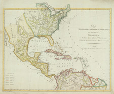
An Early Louisiana Purchase Map
Extremely rare map centered on the Mississippi River, drawn from the map used to illustrate Berquin-Duvallon's Vue de la Colonie Espagnole du Mississippi, ou des Provinces de Louisiane et Floride Occidentale, en l'annee 1802 …
The map includes an excellent treatment of Texas and the Mississippi River Valley, Ohio River Valley and Missouri River Valleys and includes the route from the Mississippi River to Texas through S. Antonio and S. Juan de Baptista.
Alte Fort St. Louis (Old Fort St. Louis) is shown. A number of Indian Villages are shown on the Missouri, along with an unnamed Fort at the far western part of the river, which we assume to be Fort Mandan, which was constructed in November 1804, but found to have been burned to the ground on their return visit in August 1806.
Many Indian Villages located in Texas, Arkansas and Missouri, along with early Western Forts.
An excellent Louisiana Territory and early Texas map.
Rarity
This is the second example of the map we have offered in the past 25 years.

![[Texas Centennial Exposition]](https://storage.googleapis.com/raremaps/img/small/76381.jpg)