|
||

|

|
|

|
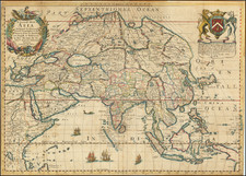
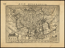
Handsome Map of Asia from Golden Age of Dutch Cartography
Fine example of Carol Allard’s map of “exact Asia, divided into its principal regions,” published in Amsterdam in 1695.
This map marked a substantial step forward in the mapping of Asia, especially in the northeast. It was published as part of a series of continental maps, which included sheets showing Africa, Europe, and the Americas.
This map portrays all of continental and insular Asia and includes parts of Europe, Africa, and Australia, which is labelled “Hollandia Nova.” The map is tightly framed around the landmasses, with Japan hugging the eastern edge of the map. North of Japan are a series of islands. These include Yedso, a misunderstood exaggeration of Hokkaido common on maps of this period, and Compagnies and Staten Islands, two islands that were sighted by the Dutchman de Vries on his 1643 voyage to find fantastical new lands in the North Pacific.
An inset in the top left-hand corner of the map portrays the furthest northwest protrusion of the Asian continent into the Arctic Sea, which is cut off of the main map by the upper margin. A peninsula with no defined end is labeled “Ys Caep’t uyn Eyndt van dit Hooft is onbekendt” or “Ice cap, the head of which is unknown.” This text, which is unique on a map that otherwise only has place names, seems to indicate what Allard a Northeast Passage from Europe to Asia. Such a possibility fascinated many seventeenth-century Europeans, but it proved elusive and un-navigable until centuries later.
Primarily a political map, the various polities and regions of Asia, as understood at the time, are brightly colored. These polities are further divided into regions and are crisscrossed with trade routes and dotted with cities. However, coastlines, waterways, mountains, forests, deserts, and other topographic features are also depicted in finely-wrought detail.
The principal decorative element of the map is the large title cartouche in the bottom left-hand corner, in which the fabulous wealth and exoticness of Asia are emphasized. Large, vignette-heavy cartouches were a common characteristic of Allard maps.
A small compass rose is located on the far right-hand side of the map. The map has narrow margins and is overlaid with a graticule of longitude and latitude.
Mapping the high tide of the Dutch Asian Trade
This map was published at the apogee of Dutch commercial power in Asia. Amsterdam was the headquarters of the Vereenigde Oostindische Compagnie, or the Dutch East Indies Company (VOC), while Batavia, now known as Jakarta, was its principal entrepot in the Dutch East Indies.
The cutting-edge cartographic techniques on display here were driven by Dutch maritime activities. Much detailed geographic information used in this map was brought back to the Netherlands on VOC ships. The great riches depicted in the title cartouche hint at the wealth derived from the Asian trade, especially when compared to the analogous cartouches on Allard’s contemporary maps of Africa and the Americas. What’s more, the regions where the Dutch trading presence was strongest in the late seventeenth century, notably the islands of Ceylon, Java, Sumatra, Borneo, Formosa, and Japan, as well as the Malay Peninsula are significantly oversized here. Clearly, the mercantile mindset of the mapmaker and his potential buyers is foregrounded in this map.
Elucidating Asia’s Northeast
When compared to a map of Asia published by Carol Allard’s father, Hugo, of ca. 1660, the most striking difference is the improved mapping of Northeast and Central Asia, labelled “Tartaria Magna.” Allard the Younger drew this vast region, which corresponds to much of modern Central Asia and Siberia, with a nearly unprecedented level of detail and accuracy. He acknowledges the source of this pioneering cartographic information at the bottom of the map: “extracta ex Authenticis Tabulis D. Nicolai Witsen.”
Nicolaas Witsen (1641-1717) was a Dutch statesman, mayor of Amsterdam, administrator of the VOC, and Fellow of the Royal Society. He was also a Russia expert and a sometime cartographer who was the first Western European to describe Siberia in his study Noord en Oost Tartarye. This work was in turn based on rigorous research and correspondence with the author’s contacts in Russia, including the Governor of Tobolsk, as well as with Jesuits Thomas Pereira and Ferdinand Verbiest, who spent years in Qing China.
Allard’s mapping of Tartary relies on Witsen’s 1687 six-sheet map. Given this fact, it interesting to note that the Qing Empire, which was ruled by Manchu Emperors from Tartary at the time of the map’s publishing is not shown on the map. Allard reproduced the old Ming borders shown in his father’s ca. 1660 map.
Witsen’s six-sheet map of Tartary, on which this map so heavily relies, became the standard model for the mapping of the region until the expeditions of Bering (1724-1749). For the rest of Continental Asia, Allard draws on De Wit’s maps of Asia, except that he presents a completely different configuration of the Black and Caspian Seas.
For its artistry, accuracy, attention to detail, and pioneering representation of continental Asia, this map is one of the finest examples of its age.
Carel (Carol) Allard (Allardt) (1648–1709) was an engraver and publisher based in Amsterdam. Part of a prominent family of Dutch mapmakers, publishers, and print sellers, his father was engraver and publisher Hugo Allard (1627–1684), who left his business to Carel upon his death. Carel published anything in demand, including maps, topography, ethnography, newsprints, and restrikes of old plates of artistic prints, many of which likely came from his father’s stock. In 1706, Carel gave his copperplates to his son Abraham Allard, before going bankrupt.
![ПОЛИТИЧЕСКАЯ КАРТА Азии [Political Map of Asia]](https://storage.googleapis.com/raremaps/img/small/90255.jpg)