|
||

|

|
|

|
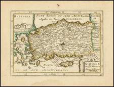
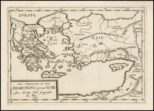
Finely engraved map of the Gulf of Alexandrette (İskenderun), on the south central coast of Turkey.
The map is oriented with east at the top.
The map appeared in Bellin's landmark 5 volume Petit Atlas Maritime, containing 580 finely detailed charts.
İskenderun, historically known as Alexandretta and Scanderoon, is a city in Hatay Province on the Mediterranean coast of Turkey. The city is named for an earlier settlement of Alexandria and Issum. The settlement was founded by Alexander the Great in 333 BC to supersede Myriandus as the key to the Syrian Gates. Alexander camped in the highlands of İskenderun, around Esentepe, and then ordered the city to be established and named Alexandria.
The bishopric of Alexandria Minor was a suffragan of Anazarbus, the capital and so also the ecclesiastical metropolis of the Roman province of Cilicia Secunda.
During the under the Ottoman Empire, in 1606, the army of General Kuyucu Murat Pasha suppressed the Jelali revolts. The Ottomans continued to fortify the city, and the remains of the early 17th-century Ottoman castle walls can still be seen where the Güzün stream crosses the Varyant road. The city was well described in 1675 by the English naval chaplain Henry Teonge in his diary. The next army to cross the Belen Pass and attack Anatolia through here were the Egyptians of Muhammad Ali in 1832.
Jacques-Nicolas Bellin (1703-1772) was among the most important mapmakers of the eighteenth century. In 1721, at only the age of 18, he was appointed Hydrographer to the French Navy. In August 1741, he became the first Ingénieur de la Marine of the Dépôt des cartes et plans de la Marine (the French Hydrographic Office) and was named Official Hydrographer of the French King.
During his term as Official Hydrographer, the Dépôt was the one of the most active centers for the production of sea charts and maps in Europe. Their output included a folio-format sea atlas of France, the Neptune Francois. He also produced a number of sea atlases of the world, including the Atlas Maritime and the Hydrographie Francaise. These gained fame and distinction all over Europe and were republished throughout the eighteenth and even in the nineteenth century.
Bellin also produced smaller format maps such as the 1764 Petit Atlas Maritime, containing 580 finely-detailed charts. He also contributed a number of maps for the 15-volume Histoire Generale des Voyages of Antoine François Prévost.
Bellin set a very high standard of workmanship and accuracy, cementing France's leading role in European cartography and geography during this period. Many of his maps were copied by other mapmakers across the continent.
![[ Bologna, Italy ] Bononia [on verso:] Bisantium Folium LXII](https://storage.googleapis.com/raremaps/img/small/101465.jpg)