


|
||

|

|
|

|
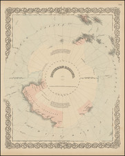
Rare and highly detailed map of the South Polar regions, published by the British Admiralty.
The map incorporates information from the 1950 survey of the Antarctic Peninsula and the The Norwegian - British - Swedish Expedition (NBSAE) of 1949-52, the first expedition in Antarctica involving an international team of scientists.
The present map is most notable for its inclusion of the various regional subdivisions of the Antarctic continent. This would seem to be the first state of the map to include all of these 5 subvisions, with the prior edition (1952) showing only two. Those listed include:
- Australian Antarctic Territory
- Terre Adelie (French Territory)
- Falkland Is. Dependencies (British Territory)
- Ross Dependency (New Zealand Territory)
- Dronning Maud Land (Norwegian Territory)
The coastal features of the continent are significantly improved, although there are still large areas which are blank or tentatively mapped. This is also the first edition to add an explanation of the currents at the top right corner.
The map was published one year after the start of Trans-Antarctic Expedition led by Sir Vivian Fuchs and supported by Sir Edmund Hillary. The Expedition undertook the first crossing of the Antarctic from the Weddell Sea to the Ross Sea via the South Pole. Sir Vivian Fuchs was sometimes known as Bunny Fuchs.
The Antarctic Treaty
The map was printed immediately prior to the Antarctic Treaty.
In 1959, 12 countries signed the Antarctic Treaty, which dedicated the whole continent to peaceful collaboration for scientific investigation. In 1961, the treaty went into effect, and all territorial claims any country had made before that time were suspended.
Rarity
The map is very rare. We were unable to locate any examples at auction or in dealer catalogs.
OCLC locates 2 copies (Newberry Library and University of Wisconsin, Milwaukee (American Geographical Society Collection)).
The British Admiralty has produced nautical charts since 1795 under the auspices of the United Kingdom Hydrographic Office (HO). Its main task was to provide the Royal Navy with navigational products and service, but since 1821 it has also sold charts to the public.
In 1795, King George III appointed Alexander Dalrymple, a pedantic geographer, to consolidate, catalogue, and improve the Royal Navy’s charts. He produced the first chart as the Hydrographer to the Admiralty in 1802. Dalrymple, known for his sticky personality, served until his death in 1808, when he was succeeded by Captain Thomas Hurd. The HO has been run by naval officers ever since.
Hurd professionalized the office and increased its efficiency. He was succeeded by the Arctic explorer Captain William Parry in 1823. By 1825, the HO was offering over seven hundred charts and views for sale. Under Parry, the HO also began to participate in exploratory expeditions. The first was a joint French-Spanish-British trip to the South Atlantic, a voyage organized in part by the Royal Society of London.
In 1829, Rear-Admiral Sir Francis Beaufort was appointed Hydrographer Royal. Under his management, the HO introduced the wind force scale named for him, as well as began issuing official tide tables (1833). It was under Beaufort that HMS Beagle completed several surveying missions, including its most famous voyage commanded by Captain FitzRoy with Charles Darwin onboard. When Beaufort retired in 1855, the HO had nearly two thousand charts in its catalog.
Later in the nineteenth century, the HO supported the Challenger expedition, which is credited with helping to found the discipline of oceanography. The HO participated in the International Meridian Conference which decided on the Greenwich Meridian as the Prime Meridian. Regulation and standardization of oceanic and navigational measures continued into the twentieth century, with the HO participating at the first International Hydrographic Organization meeting in 1921.
During World War II, the HO chart making facility moved to Taunton, the first purpose-built building it ever inhabited. In 1953, the first purpose-built survey ship went to sea, the HMS Vidal. Today, there is an entire class of survey vessels that make up the Royal Navy’s Hydrographic Squadron. The HO began to computerize their charts in the late 1960s and early 1970s. In 1968, the compilation staff also came to Taunton, and the HO continues to work from there today.
![[The Northern and Southern Skies] Hemisphaerii Borealis Coeli et Terrae Sphaerica Scenographia (and) Haemisphaerium Scenographicum Australe Coeli Stellati et Terrae](https://storage.googleapis.com/raremaps/img/small/78919.jpg)
![[ Pacific Northwest - Northwest Passage ] Limes Occidentis Quivira et Anian. 1597](https://storage.googleapis.com/raremaps/img/small/71207.jpg)