This item has been sold, but you can enter your email address to be notified if another example becomes available.


|
||

|

|
|

|
Stock# 71176
Description
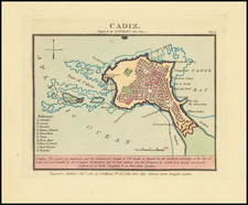
Rare harbor chart of Cadiz, published in London by John Luffman.
The map shows Rota, Porto St. Maria, Fort Saint Sebastien, Puntal Road, Carraca, and Chiclana. Includes soundings, roads and other information for mariners.
The text at the bottom notes:
Cadiz, by the Phoenecians called 'Gadir' and by the Romans 'Gades', is situated in the province of Andalusia & its harbour the best in Old Spain. It was originally built by the Tyrians and possessed successively by the Carthaginians, Romans, and Moors, the latter were dispossessed in 1260. It is 42 miles N.W. of Gibraltar. Lat. 36.30 N. Lon. 6.40 W."
![[ Basque Harbors ] Kaarte over Pasages Havn / Kaart over Byen St. Sebastian og dens Havn / Kaart over Sudlobet til Bilbao / Havenen ved Santoña](https://storage.googleapis.com/raremaps/img/small/39054se.jpg)

![[Cadiz / Columbus's Point of Departure] Gades Ab Occiduis Insulae Partibus](https://storage.googleapis.com/raremaps/img/small/79538.jpg)