|
||

|

|
|

|
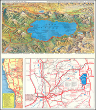
Attractive vintage pictorial bird's-eye view map of the Yellowstone National Park, produced by the Poole Brothers firm for the Chicago Milwaukee and St. Paul Railway in 1927.
The map shows all of Lake Yellowstone and the surrounding region, with particular attention paid to the connection from the CM&StP Railway line in the north, through the so-called Gallatin Gateway.
The map features a number of nice pictorial elements, most noteworthy are the series of geysers in the upper and lower geyser basins. The Lake Hotel, Canyon Hotel, Mammoth Hotel and Hot Springs, and Old Faithful Inn are all rendered pictorially.
One of the scarcer of the early-20th century railroad promotional maps of Yellowstone, this being the first time we have had it.
On the verso is an explanation of how to reach Yellowstone using the CM&StP Railway.

![[Wall Map of Jackson Lake and Environs] Topographic Map of the Grand Teton National Park Teton County - Wyoming](https://storage.googleapis.com/raremaps/img/small/99907.jpg)