


|
||

|

|
|

|
Vibrant Seventeenth-Century Map of Africa, Published in London
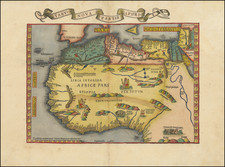
A rare and striking map of Africa, published in London by Robert Walton. The map is not recorded by either Tooley or Norwich and contains many intriguing details revealing how Europeans viewed Africa.
The present example appears without the decorative top and side panels, which in this instance were likely trimmed off near the time of publication.
This map shows the continent of Africa, from the Mediterranean coast down to the Cape of Good Hope. It also includes everything from Cape Verde (Cabo Verde) in the Atlantic to the Arabian Peninsula (Ayaman) and the Indian Ocean. The coasts form a continent that is easily recognizable to the modern eye, with only a few details still in flux, such as the shape of the southern tip of Africa and the orientation of Madagascar.
Rivers and mountain ranges cross the continent, giving the land texture and helping to orient the viewer. The most notable river is, of course, the Nile (Nilus Ri.) with its many tributaries.
The oceans, though significantly less crowded than the continent, are dotted with islands and other interesting drawings. Two ships sail on the left-hand side of the map, while imaginative sea monsters complete with tentacles, scales, and spikes can be found throughout the seas. On land, small drawings indicate the presence of elephants, camels, and lions, but none reach the size or detail of the sea creatures.
An elaborate cartouche can be found in the lower left corner, noting the map’s title, sources, cartographer, and his place of work (at the Globe and Compass in St. Paules Church yard between the two north doores) with interesting specificity. The cartouche is adorned with flora and topped by a European’s perception of an African woman, holding a bow and riding a crocodile.
Among the diligent labels can be found short descriptions of places or the people who live there. For example, in Nubia, one note says that, “In these regions lived the Queene of Sheba in the time of Solomon,” and another note near the Nile river explains that its “overflowing twise every yeare maketh the country very fruitful.” A lake placed in the center of sub-Saharan Africa (called both Zair Lake and Zembre Lake) has a note reading, “where ye Tritons and Mermaids are said to be.”
These notes indicate that this map was not intended as a simple geographic reference. Instead, its use came in its in-depth description of place and the people who lived there.
This map is modelled on the geography of Nicolaeus Visscher’s map of 1656 and the work of Joan Blaeu, with Walton's title crediting Visscher and Blaeu as direct influences. Though not cited, it is clear that the map also takes significant inspiration from John Speed and Hondius' 1625 depiction of the continent, down to the placement of the sea monsters. The dating of this map is slightly disputed, however, as the British Library example is assigned a date of 1673. A passage in the companion map of Asia strongly suggest that the map was published sometime between 1658 and 1660.
Europe and Africa in the Age of Exploration
The first European country to make a significant connection to Africa was Portugal in the fifteenth century, when Portuguese traders landed on the Gold Coast of West Africa. The original intention of these traders was to reach Asia, where many explorers hoped to travel and bring back valuable spices and silks. When they landed at the Gold Coast, these traders were happy to find the land and people so rich in gold. Thus began the trade of raw materials for African gold, which prompted the Portuguese to name the area Mina (the mine). This name can be found on the map on the coast of Guinea.
By the sixteenth century, Portugal had also begun trafficking in African slaves to bring to their plantations in the Americas. This spurred a centuries-long trans-Atlantic slave trade that other European countries took up and profited from as well. By the time this map was printed, the slave trade had been occurring for over 200 years and was an ingrained part of life for European traders and American plantation owners alike.
Despite this sad history, this map is clearly focused on the trade of goods rather than people. The various notes around the map indicate where to find gold, emeralds (Emrauds), and aloe (Aloes), among other goods.
Walton also successfully captures the combination of interesting facts and intriguing mysteries of a country that regular Europeans would know little about, having probably never visited. The notes suggest that various mythical and biblical individuals have lived on the African continent, and they make the country out to be a rich one with peoples and customs that would be strange to Europeans. With this map, Walton is tapping into Europe’s profound curiosity about and growing interest in the outside world.
![Africa / Lybia / Morland / mit allen kunigsreichen so zu unsern zeiten darin gefunden werden [Afrika/Libyen/Morenland, with all the kingdoms found therein in our time]](https://storage.googleapis.com/raremaps/img/small/95771.jpg)
![[ World & Continents ] Typus Orbis Terrarum / Americae Sive Novi Orbis Nova Descriptio / Asiae Nova Descriptio / Africae Tabula Nova / Europae](https://storage.googleapis.com/raremaps/img/small/99250.jpg)
![[Africa - Anti-Colonialism]](https://storage.googleapis.com/raremaps/img/small/66876.jpg)
![[ Africa. ] Tabula IIII. Aphricae. Hae Sunt E Cognitis Totius Orbis . . . (title on verso)](https://storage.googleapis.com/raremaps/img/small/103154.jpg)