|
||

|

|
|

|
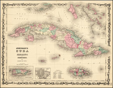
Fine, Detailed French Map of Prominent Caribbean Islands
Rare, separately-published map illustrating Hispaniola, Cuba, Martinique and Guadaloupe.
Each inset map is nicely detailed and includes a description in the title block. This text offers a brief overview of the history of each island from its initial European contact, along with important commercial, agricultural, and geographical information.
The map of Martinique includes a key that identifies parish seats, houses, sugar refineries, and water and wind mills. That of Guadeloupe has a key classifying parish seats, houses, forts, and water mills. All four maps have scale bars and show settlements, roads, mountains, and rivers. The map of Cuba is the most elaborate, with major shipping lanes also indicated.
Based on the information in the text blocks and the style of the map, it is likely this map was made between 1770, when the capital of Saint Domingue shifted from Cap‑Français to Port-au-Prince, and early 1778, when the French entered the American Revolution and then expanded their conflict to include war with Britain and Spain over colonial trade and territory in the Caribbean.
Of these islands, Cuba was never under French control. The western third of the island of Hispaniola, Saint Domingue, was France’s most lucrative colony and one of the most lucrative imperial holdings in the world. The description here lists it as “la plus riche des Antilles.” Martinique and Guadeloupe were also French holdings with significant plantation agriculture, underwritten by slave labor. Martinique, “leur plus florissante Colonie,” and Guadeloupe are still part of the French Antilles today.
Cuba
The island of Cuba was initially inhabited by the Taíno and Guanahatabey, whose populations were decimated after the coming of the Spanish. Columbus arrived on October 27, 1492. They continued to frequent the island, founding the first Spanish settlement in 1511. Havana, the eventual capital, was founded in 1515. By the time this map was made, in the mid-eighteenth century, there were 50,000 slaves at work on the island.
The French captured Havana in 1555, but the Spanish retained control of the island and repulsed the French invaders. The Spanish hold on the island was again threatened during the Seven Years’ War, when the British besieged and seized Havana in 1762. Cuba was then exchanged for Florida in the Treaty of Paris that ended the war a year later.
Saint Domingue
Christopher Columbus also plays a role in the European encounter with Hispaniola, which was one of the first places he landed in 1492. By the early seventeenth century, Hispaniola was a haven for pirates and had only a small European population. Meanwhile, the Taíno population was largely wiped out by European diseases and forced labor.
By 1606, the Spanish were losing control thanks to piracy and imperial competition. An order in that year forced settlers to move closer to the main port of Santo Domingo to avoid pirates, but this allowed French, English, and Dutch pirates to make even stronger fortifications on the north and west coasts. Via the island of Tortuga, French pirates set up a relatively permanent settlement on the mainland. This grew into plantation agriculture and was recognized by Louis XIV in 1665 and by the Spanish in 1697. The island was thus split into two colonies, Santo Domingo under the Spanish and Saint Domingue under the French.
Saint Domingue flourished and by the time this map was made was the most successful of the sugar plantations economies. There were over nearly 500,000 enslaved peoples on the island by the mid-eighteenth century. However, the island would be rocked by the Haitian Revolution which broke out in 1791; eventually, the rebels would abolish slavery and declare the Republic of Haiti, achieving the most successful slave revolt in history.
Martinique
Originally settled by Carib Indians, Columbus sighted it in 1493. In 1502, on his fourth voyage, Columbus and his men landed, leaving pigs and goats. Pierre Bélain, sieur d’Esnambuc, lay claim to the island and made it prosperous thanks to enslaved labor growing sugarcane, cotton, and cacao. In 1658, Louis XIV reclaimed direct control from Bélain’s nephew’s family. In 1664, it came under control of the French West Indies Company and then, in 1674, was named part of the French Crown’s domains. By the time this map was made, coffee had been introduced as another cash crop and, like Cuba, the island was taken and then returned to France in the Seven Years’ War.
Guadeloupe
The island was first settled by the Arawak and later the Kalina-Carib peoples. Columbus, ever present in the Caribbean, landed in November 1493. However, the native peoples fought off Spanish invasion until, in 1626, Bélain expelled the few Spanish settlers and took over. Like Martinique, control later passed to French companies and individuals. The first enslaved Africans were brought in 1650; resistance and rebellion to this oppressive regime took place immediately and repeatedly. The island was annexed to the French Crown in 1674, under the tutelage of Martinique. Also, as in Martinique, the island was captured by the British and returned at the close of the Seven Years’ War. The French were forced to forfeit their Canadian holdings in exchange for this valuable asset.
![[ Aruba ] Kaart van Het Eiland Aruba](https://storage.googleapis.com/raremaps/img/small/99929.jpg)
![West India Islands [Curacao, Trinidad, Grenada and Tobago] [4 maps on 1 sheet]](https://storage.googleapis.com/raremaps/img/small/48137.jpg)
![F.C. de Samana y Santiago. Sanchez [Santa Domingo]](https://storage.googleapis.com/raremaps/img/small/87648.jpg)
![[ Yucatan ] Pas-kaart Van de Golff de Guanaios Met 't Canaal Tusschen Yucatan en I. Cuba . . .](https://storage.googleapis.com/raremaps/img/small/99320.jpg)