


|
||

|

|
|

|
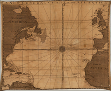
Scarce Map of the Atlantic with Sailing Routes To New York & Boston!
Fine example of Bowen's fascinating broadside map of the Atlantic, which includes a table comparing the chart with Henry Popple's great Map of the British Empire in America, first issued in 1740.
Crossing the North Atlantic, the tracks showing the "Course to New York &c." and "Course to Boston in New England", are clearly delineated.
Includes marvelous details concerning the various sailing routes of Spain and England to their various territorial possessions in the New World, along with notes regarding the Bahamas, Bermuda and the Carolinas and extensive annotations and notes regarding the British Colonies in North America and the currents of the Atlantic.
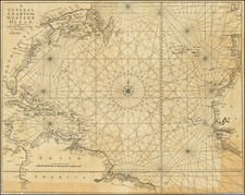
While pre-dating the Engish "discovery" of the Gulf Stream, it is clear that the quest to understand the currents in the Atlantic. The note at the top reads:
The middle of ye Ocean is at rest. The currents are only towards the Coasts & Commonly regulated by yet Winds. Without the Trade Winds the Seas is subject to Variable Winds (tho usually all Wind reigns there) & Storms. Within those Limits it is generally very Calm & ye Windsas well as Currents regular, whidch makes sailing extremely safe and pleasant: for this reason the usual Course to Virginia lies so much to the Southward.
![(South Atlantic) Nieuwe Wassende Graadige Pas-kaart van de Kust van Guinea en Brasilia strekkende van Cap Verde tot de Cap de Bon-Esperance en Verders van Rio de Berbice tot Rio de la Plata. [New Increasing Latitude Sea Chart of the Coast of Guinea and Brazil stretching from Cape Verde to the Cape of Good Hope and Further from the Berbice River to the Rio de la Plata.]](https://storage.googleapis.com/raremaps/img/small/99819.jpg)
![[Terceira Island] Tercera](https://storage.googleapis.com/raremaps/img/small/76123.jpg)