This item has been sold, but you can enter your email address to be notified if another example becomes available.


|
||

|

|
|

|
Stock# 70311
Description
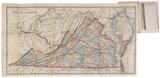
One of the earliest obtainable maps of the state of Virginia.
Shows counties, towns, roads, rivers, lakes, islands, harbors, bays, court houses, along with topographical details. Based upon Benjamin Tanner's map, which appeared in the Reid Atlas. Wheat & Brun 574.
This map appeared in Volume IV of John Payne's New and Complete Universal Geography… published in New York by John Low at the Shakespeare Head, No. 332 Water-Street, in 1799. Following the publication of Carey's American Atlas in 1795, there were a small group of 18th Century works which included a complete set of state maps, including John Reid's American Atlas, Joseph T. Scott's Gazetteer, Carey's Pocket atlas and works by Jeddidiah Morse.


![[ The Marks of Sundry of the Chief Men of Virginia ] Aliquot Heroum Virginiae Notae.](https://storage.googleapis.com/raremaps/img/small/98859.jpg)