|
||

|

|
|

|
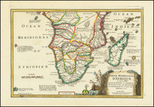
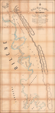
Interesting map of Southern Africa and Madagascar, covering the region from Zanzibar and Lower Guinea to Cape Colony.
A large Unrecorded Area appears in the interior, with several annotations and early information for the region. Many placenames, rivers, lakes, mountains, etc. appear. Unusually detailed for the period.
A terrific regional map, from JH Colton, one of the most prolific American mapmakers of the mid-19th Century.
G. W. & C. B. Colton was a prominent family firm of mapmakers who were leaders in the American map trade in the nineteenth century. The business was founded by Joseph Hutchins Colton (1800-1893) who bought copyrights to existing maps and oversaw their production. By the 1850s, their output had expanded to include original maps, guidebooks, atlases, and railroad maps. Joseph was succeeded by his sons, George Woolworth (1827-1901) and Charles B. Colton (1831-1916). The firm was renamed G. W. & C. B. Colton as a result. George is thought responsible for their best-known work, the General Atlas, originally published under that title in 1857. In 1898, the brothers merged their business and the firm became Colton, Ohman, & Co., which operated until 1901, when August R. Ohman took on the business alone and dropped the Colton name.