|
||

|

|
|

|
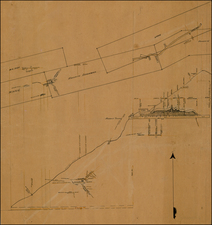
Detailed map of the Denver & Salt Lake Railroad, extending from Denver to Sulphur Springs, published by The Clasen Map Company in Denver.
The map covers most of Grand County, Boulder County, Jefferson County, Gilpin County and Clear Creek County.
The map includes a description of the "Tungsten Minerals which are important as Ores are four in number, namely: Woflramite, Ferberite, Hubnerite and Scheelite . . . ," with a lengthy description of the minerals, colors and other information.
The map was likely issued shortly after the reorganization of the line and formation of the Denver & Salt Lake Railroad, which lasted from 1913 to 1921. While named, the Denver & Salt Lake Railroad, the line never reached Salt Lake City. The focus on Tungsten suggests that the map may have been published during World War I, when the price of Tungsten increased exponentially.
Tungsten was first discovered in Colorado mines in the 1870s, but only became an important commodity in the early 20th Century. Boulder County’s Cardinal Mill was one of the nation’s first mills equipped to separate tungsten ore from its rocky shell. When World War I broke out, demand for tungsten increased exponentially. After the war ended, industrial developments and another World War caused demand to continue into mid-century.
The Moffat Road
The Colorado Encyclopedia notes as follows:
Construction on the Denver, Northwestern & Pacific Railway Hill Route, also known as the Moffat Road, began in 1904 and was completed in the late 1920s. The route connected the Front Range to Middle Park via Rollins Pass. Built in part on a former Ute Indian trail and intended as a temporary route across the Continental Divide, the arduous twenty-three-mile section of railroad served for twenty-four years before the Moffat Tunnel was completed in 1928. Since the railroad ties were taken out in the 1930s, the old railroad bed has been popular with four-wheel-drive enthusiasts and other outdoor adventurers.
* * *
. . . In 1904 the railroad thought a tunnel would take three years and $4 million, but the project’s cost and estimated construction time continued to climb. Moffat had trouble raising money for the tunnel, in part because Edward H. Harriman of the Union Pacific Railroad did everything he could to stop construction on a potential rival to his own transcontinental route. When Moffat died in 1911, his railroad had not yet reached Craig. It soon foundered, reorganized as the Denver & Salt Lake Railroad, and was ultimately acquired by the Denver & Rio Grande Western Railroad.
One reason for the railroad’s financial struggles was that it quickly became clear that the Moffat Road would be difficult to operate. Already in the winter of 1904–5, just a few months after the route was completed to Arrowhead, heavy snows prevented daily service. Despite long snow sheds and heavy-duty snowplows, the route continued to face extended closures, sometimes for several weeks at a time, whenever winter storms pounded the Continental Divide. By the 1920s snow clearance on the Moffat Road accounted for 41 percent of the route’s operating expenses.
Even in good weather, the trip over Rollins Pass proved arduous. After climbing at a 2 percent grade up South Boulder Creek from the foothills, the route shifted to a 4 percent grade as it turned away from the creek and climbed the sweeping switchbacks known as the Giant’s Ladder. Trains slowed to a crawl as they gained 2,500 vertical feet from South Boulder Creek to Rollins Pass and then rolled down 2,000 feet to Arrow, a journey that took at least two and a half hours in perfect conditions.
Nevertheless, the Moffat Road developed into a popular summer excursion from Denver. Trains regularly carried hundreds of visitors from Denver to Tolland (formerly Mammoth), where they enjoyed an eating house and a dance hall. Named for the Toll family, which owned land in the area and operated the popular Toll Inn, the weekend getaway soon grew to include other businesses and summer cabins.
The railroad station at Rollins Pass, known as Corona (“crown”), made for an even cooler summer destination. It was the highest standard-gauge railroad station in the United States. Down in sweltering Denver, the railroad advertised the station, which featured a hotel and restaurant, as the “top of the world” and “Colorado’s north pole.” Postcards pictured tourists making snowballs in July.
Rarity
The map is very rare. We are unable to locate another example.
![[ Colorado ]](https://storage.googleapis.com/raremaps/img/small/99487.jpg)
![Colton's United States of America [State of Colona named]](https://storage.googleapis.com/raremaps/img/small/90086.jpg)