
This item has been sold, but you can enter your email address to be notified if another example becomes available.


|
||

|

|
|

|
Stock# 69710
Description
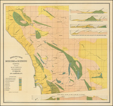
Large wall map of eastern San Diego, showing parts of Lemon Grove and La Mesa.
In the west, the map is bounded by Lake Chollas, and the Chollas Heights Naval Radio Station, which is now military housing.
There is plot level detail in the areas that had been subdivided when the map was made, though much of the area was still undeveloped when this map was made.
This map was probably originally made around 1925, though this example might be an update from the 1940s.
Condition Description
Mounted on linen and dowels. Toned, especially at top and bottom. Damspstain to lower-right corner.
![[ La Jolla ] La Jolla Street Map](https://storage.googleapis.com/raremaps/img/small/100138.jpg)
![(San Diego) Map of the Water Front of San Diego on San Diego Bay Showing the Line of Mean High Tide [National City to Old Town] [with] Map of the Water Front of San Diego on San Diego Bay Showing the Line of Mean High Tide [Midway District to Point Loma]](https://storage.googleapis.com/raremaps/img/small/95403.jpg)
![Partition of Rancho Mission of San Diego San Diego, California -- Made under Decree of Superior Court dated January 7th, 1885, By Chas. J. Fox, C.E, O.H. Borden, M.C. Woodson ] Referees. Filed January 14th 1886. J.M. Dodge, Clerk.](https://storage.googleapis.com/raremaps/img/small/101388.jpg)
![[ Old Town San Diego ] Partition Map of the lands involved in the Case of Mason et al. vs. Steele et als.](https://storage.googleapis.com/raremaps/img/small/96783.jpg)
![(San Diego Panoramic Photograph) U.S. Marine Barracks [Panoramic photograph of San Diego Marine Corps Recruiting Depot (MCRD)]](https://storage.googleapis.com/raremaps/img/small/99633.jpg)