This item has been sold, but you can enter your email address to be notified if another example becomes available.


|
||

|

|
|

|
Stock# 69646
Description
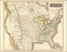
Scarce coast to coast map of the United States, showing a massive Texas and Upper California, both recently part of the United States, published in London in 1848.
Texas is shown 2 years prior to statehood, with a massive oversized northwestern extension into New Mexico Territory.
The rest of the west is "New California" (including New Mexico, Utah, Colorado, Nevada and Arizona), along with a massive Oregon Territory. Mythical Rio Buenaventura and Rio Sacramento are still shown.
Further north, the map includes an oversized Nebraska Territory, Dakota Territory and Wisconsin Territory.
This is the post-annexation Texas / pre-statehood configuration we have seen.
![[ Sonoma County ] Map of Sonoma County California Showing New Boundary Lines of County and Townships, Private Claims and Ranches, Government Townships and Section Lines, Rail Roads and Public Roads Water Works Cities Towns School Districts, etc. Carefully Compiled From The Latest Authorities By R.A. Thompson, County Clerk . . . 1884](https://storage.googleapis.com/raremaps/img/small/99877.jpg)
![[Central Riverside County] Riverside Quadrangle](https://storage.googleapis.com/raremaps/img/small/83568.jpg)
![The Rise, Progress and Prospects of the Republic of Texas [including:] Map of Texas, compiled from Surveys recorded in the Land Office of Texas, and other Official Surveys, By John Arrowsmith. [and:] A Map of the Republic of Texas and the Adjacent Territories, Indicating the Grants of Land Conceded under the Empresario System of Mexico.](https://storage.googleapis.com/raremaps/img/small/94046.jpg)