This item has been sold, but you can enter your email address to be notified if another example becomes available.


|
||

|

|
|

|
Stock# 6955
Description
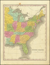
A fascinating map of the Eastern United States, depicting the time period immediately after the Louisiana Purchase. Shows Mississippi Territory prior to the formation of Alabama, an early Illinois Territory with Chicago not w/in the territorial borders and the North West Territory. The map is published using what appears to be a very early primitive brand of lithography, which had been invented in Germany in the 18th Century, but did not become popular for maps until after 1850. A scarce and interesting map.
![[Caribbean]](https://storage.googleapis.com/raremaps/img/small/85443.jpg)
![The Coast of Newfoundland From Plancentia to Cape Bonavista [and] A Draught of the River Plata in South America [and] Havana, Harbour [and] the Bay of Honda](https://storage.googleapis.com/raremaps/img/small/38599.jpg)