This item has been sold, but you can enter your email address to be notified if another example becomes available.


|
||

|

|
|

|
Stock# 6943
Description
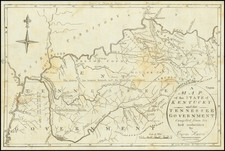
Scarce early map of Arkansas from Tanner's Universal Atlas. Shows canals, proposed canals, railroads, proposed railroads, major roads, distances, towns, rivers, etc. A key at the top of the map shows the steamboat routes and distances. Well less than half of Arkansas' counties have been established. Hot Springs County extends from Saline Creek to the western border with Texas. A few spots of minor foxling, else an excellent example of this increasingly scarce map.