|
||

|

|
|

|
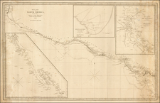
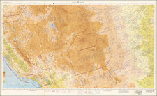
A scarce map of Baja California, northwestern Mexico, and southern Arizona. The map is detailed, showing many settlements, mountain ranges, islands, missions, and much more. California is shown as a peninsula.
The California as an Island in its most famous format fallacy dates from Michiel Colijn's 1622 map, as featured on the title page of his work on the Americas. Despite California being known to be a peninsula since the time of Cortes, many subsequent 17th century maps chose to propagate Colijn's view. Travels by Jesuit scholars in the early 18th century would help to remedy this error. Father Eusebio Kino's map "A Passage by Land to California" showed the true nature of the Baja Peninsula, and was published following his 1701 travels. However, it would take at least fifty more years for most maps to show California in such a manner, as the momentum of a century of cartography was difficult to change.
This present work was based on Venegas's Noticia de la California, which was informed by Father Consag's updates to Kino's map.
Interestingly, the present map names the several Indian tribes which occupied the area. This includes the Cochimi, Apache, Pericu, and Yuma. Much of what is known about some of these tribes today comes from Jesuit works and contemporary sources, such as this map.
This example of the map appeared in the Dutch edition of Bellin's Histoire Generale (Tom XXII).
![[ Before The Salton Sea ] [ Official Map of San Diego County compiled from latest official maps of U.S. surveys, railroad and irrigation surveys, county records, and other reliable sources . . . Northeast Sheet ]](https://storage.googleapis.com/raremaps/img/small/101378.jpg)