|
||

|

|
|

|
Land Given to Baron von Steuben -- George Washington's Chief of Staff
Rare early cadastral map of the Steuben Patent, granted to Revolutionary War hero Baron Von Steuben for His Service As George Washington's Chief of Staff During the American Revolution.
The map is nearly identical to a survey in the hand of early New York city surveyor Casimir Goerck, and appears to have his name written at the bottom right, which is very similar to the signature on this example of the map: https://www.raremaps.com/gallery/detail/39268fb
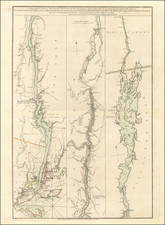
Finely executed map of the Township of Steuben, New York, showing the original patent of 16,000 acres granted Baron von Steuben lands, as surveyed in the Spring of 1787 by James Cockburn.
This finely executed survey map locates the 160 lots created by Cockburn and locates dozens of lots purchased by early land owners, in some instances showing both the original owner and a subsequent owner.
The original map was likely created circa 1789, shortly after Baron von Steuben acquired land in the region from the State of New York and commenced land sales. On May 5, 1786, the New York State Legislature passed a law providing for the sale of lands belonging to the state. One section of the law authorized the commissioners to grant to Baron Friedrich Wilhelm von Steuben a tract of 16,000 acres in any township laid out in accordance with the act. Baron von Steuben selected a section of land which he believe would be near the portage at Fort Stanwix, but in fact wound up with a tract 5 miles north of the Mohawk River. James Cockburn surveyed the tract in the spring of 1787, creating 160 lots of approximately 100 acres each.
In 1787, von Steuben retained Samuel Sizer of Springfield Massachusetts to build a house, fence in 60 acres and build a saw mill. Because the land selected was not on the Mohawk, Steuben had difficulty selling land and was compelled to give away 20 farms to accelerate the settlement process.
Friedrich Wilhelm August Heinrich Ferdinand Steuben
Baron von Steuben (1730-1794), was a Prussian-born American military officer. He served as inspector general and Major General of the Continental Army during the American Revolutionary War. He is credited with being one of the fathers of the Continental Army in teaching them the essentials of military drills, tactics, and disciplines. He served as George Washington's chief of staff in the final years of the Revolution.
Von Steuben was instrumental in many of the American victories, including the defeat of the British at Yorktown in 1781, where the Baron received the overture of capitulation from the British General Cornwallis. During 1778-1779, von Steuben prepared a complete set of regulations for Continental troops, the "Blue Book", which became the United States Army training manual. In 1783, von Steuben became an American citizen. In 1784, von Steuben was discharged from the military with honor, and turned his energies to preparing for the defense of New York Harbor and designing the plans for a military academy that were later realized at West Point. In 1788, the State of New York, wishing to express its gratitude for his service, granted him 16,000 acres north of the Mohawk River.
Casimir Goerck
Casimir Goerck was a American Surveyor active in the 1780s and 1790s in New York. He is perhaps best known for his survey work in New York City and his role in production of the Mangin-Goerck Plan of New York City, first published in 1803. Casimir Goerck made surveys in 1785 and 1796, that became the foundation for the future gridded street scheme for Manhattan. The city's leaders intended the orderly design to increase the value of the land by eliminating haphazard street networks, especially in the northern areas, which left some plots unconnected to roads. In 1797, Goerck collaborated with Joseph François Mangin to produce New York City's first real estate map, the huge Mangin-Goerck Plan. Goerck's death at the end of 1798 left Mangin to complete the map alone.