|
||

|

|
|

|
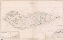
This is an antique map of the upper portion of the Red Sea, referred to on the map as the Sea of Arabia, stretching from the Suez Gulf and the Gulf of Aqabas of to approximately the latitude of Medina. This region, one of the most important shipping lanes in the world, extends to the northeast to parts of Israel, and in the northwest to the soon to be built Suez Canal. The work was originally included in Karl Muller's Geographi Graeci minores, alongside many other maps of the region.
The map is highly detailed, showing many settlements, mountains, wadis, and more. Most interestingly, Muller provides Ptolomeic coordinates for some of these, and the map credits Agartachidemis, Arthemidorum, Pliny, and Ptolomy as its sources. Place names given range from Arabic to Greek. Five insets are provided, including one of the Straits of Tiran. Two panorama views, one showing the Sinai, are provided. In all, this is a nice decorative chart of the region.
Karl Muller's Geographi Graeci minores appears to be a partial attempt to collect the vast geographical knowledge of the Greeks. He describes provides some new translations, describes the knowledge of the ancients, and compares his findings to modern geography. The work was published at a time when the studies of the ancient world were just starting to be done in a modern fashion.
Works such as Muller's are an often-underutilized source of knowledge regarding the antiquities. Fenet states that "The majority of the nautical voyages collated by Muller need modern and detailed commentary. Recent publications have started to use these types of sources more frequently." In all, this is work and map were an important early modern study on the subject.

![[Empire of Alexander The Great] Antiquor? Imperiorum Tabula in qua prae caeteris, Macendonia seu Alexandri Magni et Expeditiones exarantur . . .](https://storage.googleapis.com/raremaps/img/small/70608.jpg)
![[Arabia] Tabula Asiae VI](https://storage.googleapis.com/raremaps/img/small/87151.jpg)