|
||

|

|
|

|
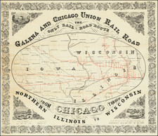
This is a rare map of Illinois displaying the region's railroad lines less than two decades after they first appeared in the state. The growth of railroads in the state would be a huge boon for Illinois and the midwest, and by the mid-1850s they were already central to the state's economy.
This map does everything that one would expect from a good regional rail map. We see existing routes, already encompassing several thousands of miles of track, as well as proposed lines. The existing lines mostly radiate outwards from Chicago, with Springfield and St. Louis as other hubs in the area. A lengthy index along the right of the map indicates the name of all the stations in the state, while a shorter index on the left names the many lines that operate in the state. An inset shows railroads operating in Indiana, Ohio, southern Michigan, and into New York.
The map is attractively designed with a decorative border. On Lake Michigan, a ship is portrayed and a note states that traffic is "Direct by way of R. St. Laurence to Europe."
Railroads were an unpredictable business at the time, a source of great profits but also large risks. Many routes that connected smaller cities would prove unsuccessful, for example, the still uncompleted Terre Haute and Alton Line would go bankrupt by 1862.
While parts of the nation would benefit more than others from the arrival of the railroads, no place would profit more so than Chicago. Early railroads connected Chicago to lead mines, wheat fields, and other local industries. Soon, however, railroad lines reaching the city from the east would replace steamboats as the primary means of transporting people and goods to the Atlantic coast. Railroads reaching Chicago from the south and the plains would give rise to meatpacking industries, and railroads from the west cement Chicago's place as the logical center of the American railroad system.
The map was published by D. B. Cooke and lithographed by H. Acheson. The latter's offices were located just next to Great Central Station, which would be built a year after the publication of this map.
Rarity
OCLC locates only six institutional copies of this map.
![[ Auburn Park / Chicago ] Eggleston, Mallette & Brownell's Property](https://storage.googleapis.com/raremaps/img/small/57703.jpg)