|
||

|

|
|

|
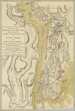
One of the Very First Maps of the First New York Subway Line.
An important antique map of Manhattan, illustrating the first subway line in New York inaugurated in 1904. The map shows Manhattan south of 96th street and shows parts of Brooklyn, Hoboken, and Weehawken. Manhattan is crisscrossed by a series of elevated and electric railways, but with only one subway line. This is the original Interborough Rapid Transit line, commencing at City Hall and following Fourth (i.e. Park) Avenue to Broadway and the Upper West Side.
The map was produced by the Broadway Central Hotel as an advertisement for its services; it advertises itself as the "Largest [hotel] in New York and of the Great Hotels of the World." This hotel, originally the Grand Central Hotel, would exist for just over a century, with its ill-fated history starting two years after opening with the murder of the stockbroker of James Fisk and ending with a building collapse in 1973. The sights of New York are described in the extensive text on the verso, and depictions of some of the most famous landmarks of the city abound.
Dating the Map
Previous editions of this map date to at least as early as the 1890s, when it was then used as a promotional piece focusing on New York City transit. See this example from our archive.
It would make sense that this map was reissued in the inaugural year of the New York Subway; the focus of the map was city transit, and the new subway line ran right past the Broadway Central Hotel. Furthermore, we have found nothing on the map that would date it to after 1904. For instance, the new Wanamaker Department store (built in 1907) is not the one listed on the map, nor is the extension of the IRT line across the East River (1908) shown.
Near Grand Central Depot, Bryant Park, and the Public Library are shown. The reservoir at that location had been removed in 1900, prior to commencement of construction of the New York Public Library on 42nd Street, which started in 1902. Thus, we have a narrow window between 1902 and 1907 for dating, and circumstantial evidence strongly suggests 1904.
![Vereinigte Staaten von Nord-Amerika [Views of New York City and Back Country Scenes]](https://storage.googleapis.com/raremaps/img/small/25442.jpg)