|
||

|

|
|

|
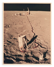
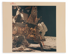
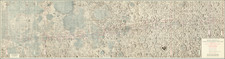
Very rare separate map for Apollo 12's EVA 2 (Extravehicular Activity 2), the second lunar expedition of the second successful manned mission to the Moon.
The map illustrates a roughly 3-hour walk on the moon, with seven named landmarks, numerous times noted (presumably to make sure the EVA was on schedule), and the location of the Lunar Module noted.
The Lunar and Planetary Institute says of the second Apollo 12 EVA:
On the second EVA, the crew explored the landing site out to a distance of 1300 feet from the lunar module. This included a stop at Surveyor 3, where they collected several pieces of the spacecraft for return to Earth to assess the effects that 2 ½ years of exposure on the lunar surface had on Surveyor. During the two EVAs combined, Conrad and Bean collected 75 pounds of lunar samples. These rocks are essentially all basalt, a common type of volcanic rock, and are indeed different in composition (less titanium) and younger (3.1-3.3 billion years) than the 3.6-3.9 billion year old Apollo 11 samples.
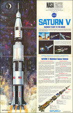
Despite being struck twice by lightning in the first minute after launch, Apollo 12 went on to perform the second successful human landing on the moon.
The map was prepared by the Mapping Sciences Laboratory, Science & Applications Directorate, at the Manned Spacecraft Center.
![[Moon rock or boulder from the Apollo 16 mission, numbered AS16-108-17694.]](https://storage.googleapis.com/raremaps/img/small/93459.jpg)
![Apollo Earth Orbit Chart (AEO) Apollo Mission 8. Sheet 1 of 3, Contains Revolution 1. For December 1968 Launch Dates [with:] Sheet 2 of 3, Contains Revolution 2. For December 1968 Launch Dates [and: Sheet 3 of 3, Contains Revolution 3. For December 1968 Launch Dates]](https://storage.googleapis.com/raremaps/img/small/95707.jpg)