|
||

|

|
|

|
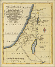
This is a map showing Palestine during the period of the Mandate, an era for which single maps of the region are scarce on the market. Palestine is pictured here from Acre to the Dead Sea, with parts of Sinai, Jordan, Lebanon, and Syria all visible. Three insets are provided, those of Haifa, Jerusalem, and Jaffa and Tel Aviv. Major roads, railways, cities, towns, and rivers are all shown, and the map is shaded according to topography. The map is targeted at motor tourists, and the start of the Israeli/Palestinian highway system is visible.
The three insets provide an attractive complement to this map. The map of Jerusalem is particularly detailed, labeling not only the many features of the walled city including the Wailing Wall, the Church of the Holy Sepulchre, and the Dome of the Rock, but also features like courts, pools, and a YMCA. Moving to the map of Tel Aviv, despite being founded as a suburb of Jaffa only thirty years prior, the younger city has more than surpassed this older city in size. Yet, the extent of both cities is still relatively limited, and they do not yet comprise the major metropolis of today.
The map shows Palestine at one of the key points in its history. Mandatory Palestine had been created in 1920 as a result of the Sykes-Picot Agreement following World War I, but had various deep-seated issues. At the time this map was created, two separate revolts were occurring against the British colonial government for two very different reasons. The 1936 to 1939 Arab revolt was waged due to the open-ended policies allowing extensive Jewish migration and the goal of creating a "Jewish National Home." The Jewish insurgency, on the other hand, was fought for exactly the opposite purpose. The White Paper of 1939, which acted as a compromise and promised independence and a binational state for Palestine and the creation of a homeland for Jewish settlers but restricted new Jewish immigration, only acted as gasoline on this fire. The compromise did not satisfy either side, and fighting continued during and after World War II.