|
||

|

|
|

|
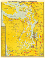
Rare large lithographed folding map showing land ownership opportunities in eastern Washington State and western Idaho, published to promote the lands owned and serviced by the Northern Pacific Railroad.
The map is focused on the the growing agricultural regions of Eastern Washington and Northwestern Idaho, and specifically the land available for purchase from either the Northern Pacific Railroad or neighboring US Government Lands, with a key identifying the status of each township and section. The fast majority of the region has been surveyed into townships, but a few unsurveyed areas remain. A number of early towns appear on the map.
In the north, the Colville Indian Reservation and Spokane Indian Reservation are shown, with the Coeur D'Alene Indian Reservation and Nez Perce Indian Reservation appearing in the east and the Yakima and Umatilla Reservations shown in the southwestern part of the map.
An inset map in the upper-right corner shows the full breadth of the Northern Pacific Railroad System.
The map differentiates between N.P.R.R. Co. Lands, N.P.R.R. Co. Lands Sold, U.S. Government Lands, U.S. Government Lands Entered, and School Sections.
When folded the pamphlet reads: "The Northern Pacific Railroad. With Its Connecting Lines," and includes a description of Washington, the Evergreen State, promoting immigration and farm land opportunities. The text includes descriptions of government land programs and terms of sale for interested purchasers, along with a large overview map of Washington and Oregon and numerous black and white photos and engraved illustrations.
![[ Utah Territory and the Great Plains ] Maps / Stansbury's Expedition / Map of the Great Salt Lake and Adjacent Country in the Territory of Utah . . . (and) Map of a Reconnaissance between Fort Leavenworth on the Missouri River and the Great Salt Lake of Utah made in 1849 and 1850 . . .](https://storage.googleapis.com/raremaps/img/small/88490.jpg)
![[California / Washington / Oregon] Pacific Highway Maps](https://storage.googleapis.com/raremaps/img/small/89058.jpg)
![[Seattle's First Zoning Ordinance] Zoning Ordinance of the City of Seattle Effective July 27, 1923](https://storage.googleapis.com/raremaps/img/small/69390.jpg)