


|
||

|

|
|

|
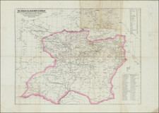
Beautiful color-lithographed folding map of Mexico, produced by Felipe Labadie and lithographed by Britton & Rey, in San Francisco in 1884.
The focus of the map is on the extensive communications networks that had recently been constructed (or were currently under construction) throughout Mexico. The legend in the lower-left elaborates this point; it mentions railroads completed; wagon roads; state boundaries; international boundaries; railroads in construction; telegraphs; submarine cables; steamship lines; the red numbers on the map record the distance to Mexico City in miles; and the W.F. markers indicate offices of Wells Fargo.
This map was published at the end of the González Interregnum, the period between 1880 and 1884 when General Manuel González held the presidency after Porfirio Díaz had stepped down. The period was marked by increasing openness to investment by U.S. nationals and an attempt by the Mexican government to make the country seem like a safe and attractive place to invest. This map clearly means to advance that cause by displaying Mexico's advanced national communications network.
In 1885, Felipe Labadie was acting as Mexican Consul in San Francisco.
Rarity
OCLC records one example at the Bancroft Library, UC Berkeley. The Library of Congress has a pen-and-ink tracing of the map.
![(Second French Intervention in Mexico - Manuscript Map) Michoacan [and parts of Guanajuato and the Bajío region of Mexico]](https://storage.googleapis.com/raremaps/img/small/86018.jpg)
![(Mexican Antiquities - Photography) [South Side of Nun's Palace, Uxmal; Palais Des Nonnes, à Uxmal; cote sud] [Plate 42 from:] Cités et Ruines Américaines](https://storage.googleapis.com/raremaps/img/small/93938.jpg)