|
||

|

|
|

|
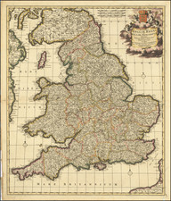
"Note. This Map has been Copied four times very confused and Scandalously."
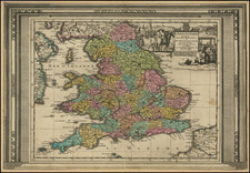
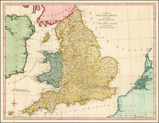
An antique example of Thomas and John Bowles edition of Herman Moll's small road map of England and Wales. The detail is extensive, with many smaller market towns and minor crossroads shown. The map is subdivided by historic counties, which makes for interesting comparisons to modern maps. London is split between Surrey, Kent, Essex, and "Midlsex." Yorkshire is massive, though the three ridings are noted. The map shows England and Wales in full, with parts of Scotland, France, and Ireland around the edges.
There is an attractive dedicatory cartouche in the lower-left corner stating, "To His Royal Higness [sic] Frederick Prince of Wales." A chart in the upper left lists each county by size, along with their area, length, and breadth. An extensive legend is provided, and the distances along roads are even included, though not always very accurately.
The map includes an interesting note regarding plagiarism in mid-18th century English mapmaking stating that the map had been subject to four unauthorized copies. Plagiarism at the time was a topic of debate between printers and retailers, with the first copyright act published in 1710 under Queen Anne. Enforcement was non-existent at first, and it would take until the end of the century for modern statutes to be accepted.
Herman Moll (c. 1654-1732) was one of the most important London mapmakers in the first half of the eighteenth century. Moll was probably born in Bremen, Germany, around 1654. He moved to London to escape the Scanian Wars. His earliest work was as an engraver for Moses Pitt on the production of the English Atlas, a failed work which landed Pitt in debtor's prison. Moll also engraved for Sir Jonas Moore, Grenville Collins, John Adair, and the Seller & Price firm. He published his first original maps in the early 1680s and had set up his own shop by the 1690s.
Moll's work quickly helped him become a member of a group which congregated at Jonathan's Coffee House at Number 20 Exchange Alley, Cornhill, where speculators met to trade stock. Moll's circle included the scientist Robert Hooke, the archaeologist William Stuckley, the authors Jonathan Swift and Daniel Defoe, and the intellectually-gifted pirates William Dampier, Woodes Rogers and William Hacke. From these contacts, Moll gained a great deal of privileged information that was included in his maps.
Over the course of his career, he published dozens of geographies, atlases, and histories, not to mention numerous sheet maps. His most famous works are Atlas Geographus, a monthly magazine that ran from 1708 to 1717, and The World Described (1715-54). He also frequently made maps for books, including those of Dampier’s publications and Swift’s Gulliver’s Travels. Moll died in 1732. It is likely that his plates passed to another contemporary, Thomas Bowles, after this death.
![[ United Kingdom ] Tabula Prima Europae](https://storage.googleapis.com/raremaps/img/small/78537.jpg)
![[English Channel] De Cust van Vlaenderen en Engelandt van Oostende tot deur de Hoofden](https://storage.googleapis.com/raremaps/img/small/75243.jpg)