|
||

|

|
|

|
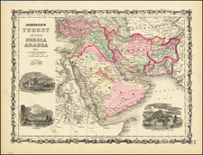
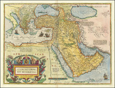
This is a great map of the Middle East published the year of the Yom Kippur War. While it is uncertain for what purposes this map was published, it shows Israel surrounded by a sea of Arab states. Israel is shown in full possession of the Sinai Peninsula, with the Suez Canal acting as a boundary between Israel and Egypt.
The centerpiece of this work is a large-scale political map of the Middle East. Six inset maps are provided, and these are particularly interesting. These include a map of Israel (showing it in possession of the Sinai), a vegetation map with numerous features, such as oases, marked, a topographical map, a map of oil production and pipelines, a population map showing ethnic representations, and a map possibly showing ethnographic or religious information. Two charts breakdown the populations and economies of the various nations of the region in more detail.
The 1973 date for this map is auspicious. While no direct mentions of the Yom Kippur War appear to be made, this map was created during a period when the tensions in the region it shows were reaching new heights. The war would be launched as a surprise attack in October, during the Ramadan period and, of course, on Yom Kippur. Egyptian troops initially managed to recapture the Sinai, and losses were suffered by the Israeli army, which had become overconfident after the earlier six-day war. However, within two weeks, Israeli forces managed to maneuver across the Suez Canal and retake back most of the Sinai. While a strategic victory for Israel, the war showed that the Defense Forces were not invincible, and was a major factor in leading to the Camp David accords of 1978.
The map names its various Hebrew- and English-language sources in the center-left of the map.