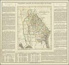
![Neueste Karte von Georgia mit seinen Strassen, Eisenbahnen und Entfernungen 1845. [Latest Map of Georgia with its Roads, Railways, and Distances 1845.] By Joseph Meyer](https://storage.googleapis.com/raremaps/img/small/94441.jpg)


|
||

|

|
|

|
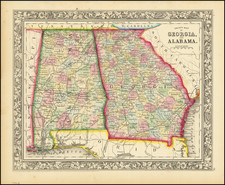
Antique map of Georgia with German language description. Purporting to show the routes, railroads, and distances in the state, it shows various other features including rivers, canals, and even gold mines in intricate detail. The names and outlines of the counties at the time are shown. The adjoining states of Florida, Alabama, Tennessee, and the Carolina are portrayed in part.
An inlay provides the distances to various towns along the Savannah to Augusta and the Savannah to Charleston routes. Conversions to other measures of distance are included.
Joseph Meyer (1796-1856) was a German publisher who released Meyers Konversations-Lexikon, a German-language encyclopedia in print from 1839 to 1984. Meyer was born in Gotha and educated as a merchant in Frankfurt, an important city in the book trade. He traveled in London in 1816 and was back in German in 1820, where he began to invest in textiles and railways. He opened his publishing operation, Bibliographisches Institut, in 1826. His publications each had a serial number, a new innovation at the time. He was best known for his atlases and the Meyers Universum (1833-1861), which featured steel-engravings of the world. The Universum stretched to 17 volumes in 12 languages and was subscribed to by 80,000 people all over Europe. Thanks to his publishing success, Meyer moved the Institut from Gotha to Hildburghausen in 1828. Meyer died in the latter city in 1856.