|
||

|

|
|

|
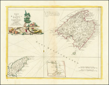
Beautiful antique map of Menorca, Majorca, and Ibiza, with inset maps of the fortress of Saint-Philip, the Harbor of Mahon, and the general western Mediterranean.
The map was probably published on the occasion of the Siege of Fort Saint Philip (1756), about which Wikipedia gives the following summary:
A French force under the command of the Duke de Richelieu landed on the island and besieged the British garrison at St. Philip's Castle, forcing them to surrender after a lengthy siege. A British relief force under Admiral John Byng sailed with the purpose of saving the island, but after the naval Battle of Minorca, Byng withdrew to Gibraltar, and the resistance of the garrison finally collapsed. Byng was later blamed for the loss of Menorca (historically called "Minorca" by the British), and executed by firing squad. One involved in the British navy in this operation was Arthur Phillip, later to be first Governor of New South Wales.
The garrison's resistance had been considered lengthy and honourable enough for them to be allowed to march out carrying their arms and be shipped back home to Britain, a common convention at the time. Blakeney was absolved of any blame for the loss of the island, and was later awarded an Irish peerage in recognition of his defence of Fort St Phillip.
![Les Estats de la Couronne d'Arragon en Espagne ou sont l'Arragon Royaume, la Catalogne Princip[au]té, la Valence Royaume, et les Isles de Maiorque... 1653](https://storage.googleapis.com/raremaps/img/small/80239.jpg)