|
||

|

|
|

|
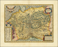
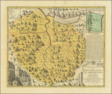
The Most Important Map of Alsace of the 16th Century
Important early map of the Alsace Region, by Daniel Speckle in Strassburg in 1576. Originally commissioned by the Archduke Ferdinand in 1573, it is widely considered the most important map of the region at the time.
The map follows the course of the Rhein River from Basil to the area just south of Phillipsburg and centered on Strasbourg.
The plates for the map survived until about 1870 in the Strasbourg Stadtbiblithek.
Specklin's map is the source map for Ortelius' Argentoratensis Agri Descriptio.
https://www.raremaps.com/gallery/detail/61818
Daniel Speckle or Specklin was born and lived in Alsace.
Sone of the wood carver Veit Rudolf Speckle, Daniel was apprenticed to become a silk embroiderer. In 1554, he traveled to Koramon, Hungary, where he worked as a journeyman with Italian Pietro Ferrabosco during the conversion of an old castle into a fortress.
Over the next few years, he developed an expertise in fortress construction, with the assistance of Viennese Hermes Schallautzer. He travelled thereafter to Transylvania, Denmark, Sweden, Poland and Russia in furtherance of his skills.
In 1567, he was involved in buidling fortifications in Dusseldorf and Regensburg. Thereafter, under the patronage of Imperial General Lazarus von Schwendi, he planned the fortresses at Varazdin, Kashau and Tokai in Hungary.
In these years, he also acquired mapmaking skills. In 1573, he was commissioned by Archduke Ferdinand to produce a map of Alace, which he completed in 1576.
Over the rest of his lifetime, he became one of the most important engineers in Europe. His Architectura von Vestungen was considered the most important work of the period on this topic.
![[Lake Neuchâtel]](https://storage.googleapis.com/raremaps/img/small/73670.jpg)