|
||

|

|
|

|
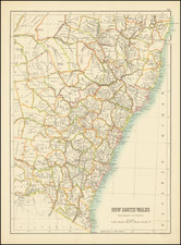
Finely detailed map of the Southeastern part of Australia, by John Arrowsmith. This is the second of the two maps which would be utilized to illustrate the extraordinary growth of this part of Australia during the early period of the Australian Gold Rush.
First issued in 1838, Arrowsmith's South Eastern Portion of Australia, provides a fine template for the fast-moving changes in this part of Australia.
By 1839 John Arrowsmith had produced . . . "The South Eastern portion of Australia, compiled from the Colonial Surveys and from details furnished by Exploratory Expeditions." This map covers almost the same area as Arrowsmith's Discoveries in Australia, that is, from the Brisbane region south to Spencer Gulf in South Australia, but at the larger scale . . .
This new map had a life of 20 years from 1838 until 1858 and in this time it went through twelve states. The principal changes are the defining of the major river systems of the south-east region of Australia, and the development of settlement through the southern part of New South Wales which in 1851 became the colony of Victoria. The coastal areas of New South Wales proper are explored and settled but the hinterland remains undeveloped. The changes in the south-east area of South Australia are minimal and confined to the coastal areas of the Fleurieu Peninsula. This map also appeared in two different states in the Parliamentary Papers of 1852 and 1853 where the map was updated to show the location of Gold Fields in New South Wales (Further papers, 1852 and 1853). It remained one of Arrowsmith's most important depictions of south-east Australia. The various states of this map have been grouped by date into separate chapters, i.e. 1838, the 1840s and the 1850s.
For an overview of states of the map, see the following link: http:// http://www.asmp.esrc.unimelb.edu.au/biogs/E000092b.htm
The Arrowsmiths were a cartographic dynasty which operated from the late-eighteenth century to the mid-nineteenth. The family business was founded by Aaron Arrowsmith (1750-1823), who was renowned for carefully prepared and meticulously updated maps, globes, and charts. He created many maps that covered multiple sheets and which were massive in total size. His spare yet exacting style was recognized around the world and mapmakers from other countries, especially the young country of the United States, sought his maps and charts as exemplars for their own work.
Aaron Arrowsmith was born in County Durham in 1750. He came to London for work around 1770, where he found employment as a surveyor for the city’s mapmakers. By 1790, he had set up his own shop which specialized in general charts. Arrowsmith had five premises in his career, most of which were located on or near Soho Square, a neighborhood the led him to rub shoulders with the likes of Joseph Banks, the naturalist, and Matthew Flinders, the hydrographer.
Through his business ties and employment at the Hydrographic Office, Arrowsmith made other important relationships with Alexander Dalrymple, the Hudson’s Bay Company, and others entities. In 1810 he became Hydrographer to the Prince of Wales and, in 1820, Hydrographer to the King.
Aaron Arrowsmith died in 1823, whereby the business and title of Hydrographer to the King passed to his sons, Aaron and Samuel, and, later, his nephew, John. Aaron Jr. (1802-1854) was a founder member of the Royal Geographical Society (RGS) and left the family business in 1832; instead, he enrolled at Oxford to study to become a minister. Samuel (1805-1839) joined Aaron as a partner in the business and they traded together until Aaron left for the ministry. Samuel died at age 34 in 1839; his brother presided over his funeral. The remaining stock and copper plates were bought at auction by John Arrowsmith, their cousin.
John (1790-1873) operated his own independent business after his uncle, Aaron Arrowsmith Sr., died. After 1839, John moved into the Soho premises of his uncle and cousins. John enjoyed considerable recognition in the geography and exploration community. Like Aaron Jr., John was a founder member of the RGS and would serve as its unofficial cartographer for 43 years. Several geographical features in Australia and Canada are named after him. He carried the title Hydrographer to Queen Victoria. He died in 1873 and the majority of his stock was eventually bought by Edward Stanford, who co-founded Stanford’s map shop, which is still open in Covent Garden, London today.
![[ Western Australia ] Carte de la Terre D'Edels et d'une partie De Celle D'Endracht (a la Nouvelle Hollande) Dressee Par M. L. Freycinet, Commandans la Goelette le Casuarina. (1801 & 1803) (Rare Separately Published Example)](https://storage.googleapis.com/raremaps/img/small/53267.jpg)
![[ Tasmania / Hunter Island ] Carte des Iles Hunter dressee Par L. Freycinet, Commandant la Goelette le Casuarina, d'apres ses observations et celles de Mr. Boullanger Ingenieur Hydrographe -- December 1802. (Rare separately published example)](https://storage.googleapis.com/raremaps/img/small/53891.jpg)
![Neu-Seeland [with] West Australien [with] Tasmania](https://storage.googleapis.com/raremaps/img/small/98073.jpg)
![(World - First State!) Benedict Arias Montanus Sacrae Geographiae Tabulam ex Antiquissimorum Cultor. [Pre-Dutch Discovery Depiction of Australia]](https://storage.googleapis.com/raremaps/img/small/93232.jpg)