This item has been sold, but you can enter your email address to be notified if another example becomes available.


|
||

|

|
|

|
Stock# 66618
Description
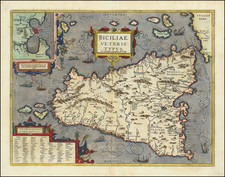
Pictorial map of Sicily showing major cities, roads, railway lines, administrative divisions, and ferry lines. Abundant drawings picturing Sicily as a beautiful agrarian island, with olives, grapes, and churches. Surrounded by the Mediterranean painted in an attractive baby blue. A useful souvenir that paints a picturesque scene of the island.
Printed as part of the 18th issue of the "Scuola Italiana Moderna," this may have been used to teach Italian schoolchildren about the geography and culture of their country.
Condition Description
Fold mark.
![[ Kingdom of Naples ] Partie Septentrionale du Royaume De Naples. Par Le St. Robert. À Venise par P. Santini 1779.](https://storage.googleapis.com/raremaps/img/small/102023.jpg)
![[Naples]](https://storage.googleapis.com/raremaps/img/small/77322.jpg)