|
||

|

|
|

|
Stock# 66617
Description
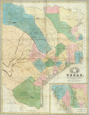
Highly detailed map of a large part of Texas and Louisiana, prepared as part of the US Government's monumental work Atlas to accompany the official records of the Union and Confederate armies, published between 1891 and 1895.
The map extends west to include Dallas, Fort Worth and Waco, covering well the details of the Upper Trinity River and Tributaries.
The map provides a magnificent treatment of the early roads in the region, along with rivers, creeks, post offices, Stage Coach stations, and a bit of topography.
Condition Description
Minor soiling.
![(Texas Mexico Borderlands) [Map of the Rio Grande, Texas - Mexico border, from the Big Bend to the town of Mier] Copiado del Mapa de S. Mc. L. Staples, 1828... Dibujado y extractado de los documentos y datos dichos, por F. L. Mier - Monterey, Diciembre de 1873.](https://storage.googleapis.com/raremaps/img/small/91667.jpg)