|
||

|

|
|

|
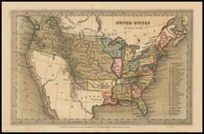
Scarce map of the newly minted United States, extending from Georgia to Maine (Sagadahok) and west to the Mississippi River.
The map is based on Robert de Vaugondy's Partie de l'Amérique Septentrionale, qui Comprend le Cours de l'Ohio, la Nlle. Angleterre, la Nlle York, le New Jersey, la Pensylvanie, le Maryland, la Virginie, la Caroline. The Carolinas and Virginia extend to the Mississippi River. Pennsylvania is enlarged and shown taking in part of New York, which in turn encompasses all of New Jersey. New England consists of only Massachusetts and New Hampshire. Lakes Huron, Ontario, and Erie appear in a largely accurate configuration.
The area below Lake Erie is called "Ohio Indians."
A large inset titled "Supplement to Carolina" features the remainder of South Carolina and parts of Georgia. Filled with Indian names.
![[ Middle British Colonies Map ] Pensilvania Maryland and Virginia](https://storage.googleapis.com/raremaps/img/small/98228.jpg)
![Map of the States of North & South Carolina [Large Charleston Inset]](https://storage.googleapis.com/raremaps/img/small/91846.jpg)