This item has been sold, but you can enter your email address to be notified if another example becomes available.


|
||

|

|
|

|
Stock# 66429
Description
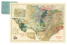
Antique Texas General Land Office map of Jefferson County, Texas. The map was prepared in 1879 by W.C. Walsh, Commissioner of the Genl. Land Office.
This example of the map has manuscript annotations related to land sales and the oil industry. Three red pencil circles have been drawn on the map, one at the Big Hill salt dome oilfield, one at the High Island oilfield, and the other at the Spindletop oilfield.
This example was owned by Galveston-based surveyor R.W. Luttrell. Luttrell was active through the initial Texas oil boom.
Condition Description
Old folds. Backed on early linen. Two ink stamps "R.W. LUTTRELL, Civil Engineer, Apr 5 1895 ---P.O. & 22nd. Street --- GALVESTON, TEXAS."
![[Texas & Oklahoma] Amer. Sep. No. 55. Partie Des Etats-Unis](https://storage.googleapis.com/raremaps/img/small/93537.jpg)
![[Printed on Linen] Map of Texas and Loyal Colonies Sometimes Referred To As The United States](https://storage.googleapis.com/raremaps/img/small/93363.jpg)