|
||

|

|
|

|
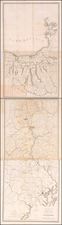
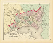
The First Map of the Federal Territory of Columbia, Site of the Nation’s Capital
Fine mid-nineteenth-century example of Andrew Ellicott’s map of the Territory of Columbia, where the nation’s capital was to be built. This example was printed thanks to a request by the Senate to reprint several foundational maps of the city.
This was the first topographical map of the territory and one of the only maps of the entire territory made for seventy years after the country’s founding.
First published in 1793, the map includes the entirety of the one hundred square miles designated for the territory. Each of the ten miles per side of the space are marked out on a square within the edge of the map. Hachures indicate the varied terrain, and important roads are included.
The Potomac snakes through the map, which includes a light outline of Pierre Enfant’s plan for Washington D. C. The location of the President’s House and the Capitol building are both labeled. Georgetown, a port, is included immediately to the west of the nascent city, with Alexandria to the south, just inside the boundaries of the territory.
Interestingly, the map is actually intended to be north-oriented, as indicated by the direction of the labels and the title in what is here the top right corner. It was meant to be viewed on the diagonal, in a diamond shape. This orientation was suggested by Thomas Jefferson, who was working with Ellicott on the plans for Washington D.C.
Andrew Ellicott and the planning of Washington D.C.
The site for Washington D.C. was chosen only after seven years of debate and negotiation about possible sites for the new nation’s capital. George Washington, a trained surveyor, selected the site along the Potomac River, which was then a central site among the existing states.
Washington’s friend, Pierre Charles L’Enfant, was appointed to plan the new city, which he modeled on a tradition of grand European parks and avenues. Andrew Ellicott surveyed the boundaries of the new territory along with Benjamin Banneker, a self-educated free black man, and Ellicott’s brother, Joseph.
L’Enfant was supposed to work under the supervision of Thomas Jefferson, then Secretary of State, and three commissioners. However, L’Enfant hated this oversight; after completing a manuscript plan of the city, now in the Library of Congress, he failed to provide a printed plan for the city in time for the initial sale of city lots in October 1791. When he still had not produced a printed plan by November, Jefferson turned to Ellicott for help.
Ellicott took over the plan and, although he kept L’Enfant’s general design, he altered it in several ways. For example, he removed many of the diagonal avenues and some plazas. L’Enfant felt slighted and he complained to Washington; he was removed as the planner of the project and Ellicott gained the post.
Ellicott’s printed plan for the city first appeared in 1792, and this map was first published in 1793. While there were several plans of the city printed, reflecting its rapid growth, this was the only official map of the Territory of Columbia printed until the later-nineteenth century.
This re-issue of the map was printed by A. B. Hamilton in 1852 at the request of the Senate. He also re-printed several other Washington maps at the same time, including Ellicott’s plan of Washington D. C. and W. C. Stone’s map of the city from 1839.
Andrew Ellicott (1754-1820) was an astronomer and surveyor. Prior to the Revolutionary War, Ellicott taught mathematics in Baltimore. A skilled surveyor, he conducted surveys of the Territory of Washington and the Mason-Dixon line. He also made the first topographical study of the Niagara River ad Falls. Ellicott was a member of the American Philosophical Society. He tutored Meriwether Lewis in astronomy before Lewis set out with Clark for their famous expedition. In 1813, Ellicott accepted a post as a professor of mathematics at West Point Academy. He died there in 1820.
![Maryland & Delaware and the District of Columbia [large Washington inset]](https://storage.googleapis.com/raremaps/img/small/100301.jpg)