|
||

|

|
|

|
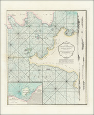
Important Seventeenth Century Map of the Indian Ocean, by Du Val
Striking map of the Indian Ocean, including Eastern and Southern Africa, Australia, Japan, and Maritime Southeast Asia. Full of detail and elegantly embellished, the map shows significant and early information about Dutch encounters with Australia.
Extending from Australia to Africa, from China and Asia Minor to Tasmania, the map captures the extent of European geographic knowledge of the region as it was known in the late-seventeenth century. The Northern Indian Ocean is full of islands, banks, and archipelagos, including the Maldives, which look almost quilted in their regularity and shape. Most of these islands were encountered by Middle Eastern, African, and Asian traders, who had navigated these waters for centuries, but also by European ships, who had plied the sea for nearly two hundred years by the time this map was published.
The outlines of the coasts of South and East Asia are very well-delineated for the time, reflecting Du Val’s skill and access to the latest maps, charts, and texts. India, Indochina and the Malay Peninsula are based on the latest Dutch East India Company (VOC) published sea charts and they present a view that is quite familiar to the modern observer. The Indonesian Archipelago is generally well formed, although New Guinea takes on a somewhat surprising, although typical for the time, shape.
Further north, Du Val relies on the map of East Asia made by his colleague, Melchisédech Thévenot, published in 1663. China is shown in a fairly informed manner. A highlight is the Great Wall, which is drawn in detail in the upper right corner, near the title cartouche. Korea is shown as a peninsula, while Japan south of Hokkaido is shown relatively accurately, if a bit horizontally stretched.
Rivers wiggle over Southeast Asia in nearly parallel, north-south lines. The largest is the Ganges, to the west, which flows through the Mogul Empire as labeled here. In Africa, another river, this time the Nile, winds from south to north. It’s source here are two large lakes, which are on either side of the Montagnes de la Lune, or Mountains of the Moon. This depiction stems from a Ptolemaic understanding of the river and all the rivers as shown here reflect that Europeans knew relatively little about inland Africa and Southeast Asia.
In addition to important and thickly-detailed depictions of both the geography and hydrography of the region, there are restrained yet sophisticated decorations, a hallmark of Du Val’s work. Stylish, almost delicate, compass roses provide a sense of orientation. In the bottom left, an ornamental trapezoid introduces the mapmaker’s address, and the year of the production of the second edition of this map, 1677 (first edition 1665). In the top center, a fashionably draped cloth bears the title and mapmaker’s name and title.
Early Dutch encounters with Australia
Du Val includes a remarkably complete outline of Australia. He does not connect New Guinea and Carpentaria, in the northeast of the continent, as many of his contemporaries would. Carpentaria was so named in 1623 by Jan Cartensz after Peiter de Carpentier, the VOC governor of the East Indies at that time.
Du Val could not know that Luís Vaz de Torres, who sailed with the Pacific explorer Pedro Fernandes de Quiros on a voyage for the Spanish in 1605, had passed through the straits between New Guinea and Australia. However, the Spanish had suppressed his report in the hopes of maintaining power via geographic secrecy and the Strait was only rediscovered by Alexander Dalrymple in 1762 when he was researching documents captured from the Spanish in the Philippines during the Seven Years’ War. Later, Cook sailed through the Strait, confirming its existence to the Western world, during his first voyage.
Looking counter-clockwise, Du Val includes a mostly uninterrupted northern coastline around to Dirk Hartogs Rée. This coast connects the two earliest Dutch ships known to have encountered the Australian continent. The information for portions of the coasts in New Guinea and northern Queensland, Australia come from the voyage of the Dutch vessel Duyfken in 1605-06. Under the command of Willem Janszoon, the Duyfken explored the eastern shore of the Gulf of Carpentaria, just below the Cape York Peninsula, a venture which was famously the first recorded European contact with Australia.
The Endracht was the second recorded European ship to contact Australia (1616), and the first in western Australia. The Endracht was blown off course en route to the East Indies in that year. It was commanded by Dirk Hartog, hence his name and the name of his ship here. Interestingly, the date of 1618 is provided, instead of 1616. The crew commemorated their discovery by erecting a post with a pewter dish inscribed with their ship’s information—the earliest physical record that historians have of any European landing in Australia.
Returning to the north coast, there is Terre d’Arnems. This refers to the Arnhem, a Dutch East India ship, which sighted the area in 1623. This was one of the two ships that sailed with Carstensz, who was mentioned in reference to Carpentaria. To the west is Terre de Wits, which recalls Gerrit Frederikszoon de Witt, captain of the Vianen, which sailed in 1628. De Witt ran aground near what is now Port Hedland. He managed to free his ship by offloading cargo and coasted southward.
Houtmans Abrolhos and Terre d’Edels farther south both refer to the same voyage. Jacob d’Edel, in the Amsterdam, along with Frederik de Houtman in the Dordrecht came within sight of the western coast and called the stretch of land d’Edelsland. The Houtmans Abrolhos are an archipelago, as shown here with x marks, and named for the navigator who sighted them, or at least it was Houtman who reported the islands to the VOC. It was here that the Batavia infamously wrecked in 1628. The name Houtmans Abrolhos, as used on this chart, was first used in Hessel Gerritszoon’s 1627 chart, Caert van't Landt van d'Eendracht. Also included on Gerritszoon’s chart is the shoal sighted by and named for the Tortelduyf, which is labeled here as Tortelduif.
Farther south, Terre de Leuuin is named for the Leeuwin, whose crew charted some of the southwest coastline in 1622; Flinders would later name Cape Leeuwin, the southwestern most point on the Australian mainland, after the ship. A note in the south mentions Pieter Nuyts, a Dutch navigator who commanded the Gulden Zeepaert along the southern coast in 1627, not 1625 as noted here.
Breaking into the frame of the map is the southeast corner is Terre d’Antoine Diemens. Now called Tasmania, the island was initially sighted by another Dutch navigator, Abel Tasman. His voyage is also referenced in the name of the entire continent, Novvelle Holande partie de la Terre Australe decouverte l’an 1644. Tasman led two expeditions in the Pacific from 1642-44. The first resulted in a loose circumnavigation of Australia, proving it was not the mythical, and massive, southern continent. He also was the first European to encounter New Zealand, on his first voyage. On the second voyage he sailed along the norther coast of Australia and near New Guinea.
Finally, a non-Dutch contribution is also noted in this area. Off of the northwest coast of Australia is a tiny cluster of three dots and flanking x’s labeled Trial. This refers to another shipwreck, that of the Trial, an English East India Company ship. Commanded by Captain John Brookes, this was Australia’s first recorded shipwreck, in 1622. The ship ran into the reefs near what today are the Montebello Islands. 45 members of the crew managed to get to Batavia in two longboats, but many more crewmen were left behind.
Despite all of these encounters, European knowledge of Australia geography remained scattered and incomplete. It would not be until the late-eighteenth and early-nineteenth centuries that the Cook, Baudin and Flinders’ expeditions, among others, would provide detailed charts of the Australian coastline.
First published in 1665, this is the second edition of the map, from Du Val's atlas, Cartes de Geographie les Plus Nouvelles (Paris, 1677).
Du Val's map is one of the finest early depictions of the Indian Ocean and an essential map for collectors in a variety of fields, notably Australia and East Asia.
Pierre Duval (1618-1683) was a French geographer, cartographer, and publisher who worked in Abbeville and Paris during the seventeenth century. He was born in the former city, in northeast France, before moving to Paris. Duval was the nephew of the famous cartographer Nicolas Sanson, from whom he learned the mapmaker's art and skills. Both men worked at the royal court, having followed the royal request for artists to relocate to Paris. In addition to numerous maps and atlases, Du Val's opus also includes geography texts. He held the title of geographe ordinaire du roi from 1650 and died in 1683, when his wife and daughters took over his business.

![[Untitled Map of Southeast Asia & The Philippines]](https://storage.googleapis.com/raremaps/img/small/47007.jpg)