|
||

|

|
|

|
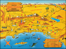
Rare and fascinating map of the Transmississippi West, from Marmocchi's Il Globo--Atlante di carte geografiche . . . , published in Genoa.
The map is engraved by Bonatti in Turin. Despite the dating, the map show a pre-Gadsden Purchase border with Mexico, following the Gila River. Oregonia occupies the entire region between the Rocky Mountains and the Pacific, bounded to the north by Nuova Bretagna. Very curious Nebraska is shown extending from the Rocky Mountains to the Missouri River and the Kansas River, with a very odd extension in the southeast corner, as it reaches Ft. Council and the Iowa Border.
Kansas extends from Arkansas and the Rio Roxo (Red River) to Yutah (Utah) and the Rio Grande and to the Nebraska River in the North. The California, New Mexico and Utah Borders are similarly misshaped. Perhaps most interesting of all is the inclusion of Arrissonia, south of the Gila River.
This is one of the earliest references to Arizona we have ever seen on a map and the only example of Arizona located south of the Mexican Border. The earliest discussions for the formation of Arizona Territory date to August 1856. However the measure was defeated in Congress in February 1857. In 1858, the New Mexico Territorial legislature adopted a resolution favoring the creation of such territory, but it was not acted upon by Congress. In April 1860, a convention was held in Tuscon, wherein the Territory was informally organized. In March 1861, the informal Territory adopted a resolution wherein the Territory joined the Confederacy. In March 1862, the United States finally adopted legislation recognizing Arizona as a Territory of the United States, which was signed into law in early 1863 (and despite the fact that the Confederacy had also claimed the Territory and a group of Texas soldiers taken possession of Fort Fillmore in Mesilla.
A fascinating look at the Transmississippi West from an Italian perspective, although the map must been seen in contrast to Marzolla's edition of the Hypolite Ferry map of Upper California, to appreciate the disparate treatment of the region by these two different Italian publishers.
![A Description of Western Texas, Published by the Galveston, Harrisburg & San Antonio Railway Company, the Sunset Route [with map:] Correct Map of Texas Published by Galveston, Harrisburg & San Antonio Railway](https://storage.googleapis.com/raremaps/img/small/86207.jpg)